| Mesoscale Discussion 1321 | |
| < Previous MD Next MD > | |

|
|
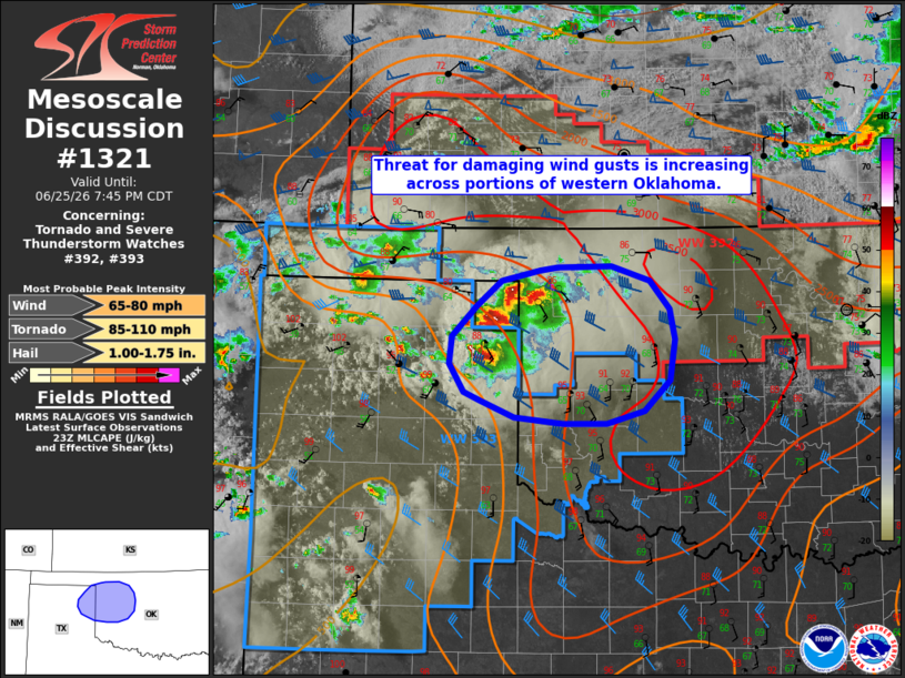
   Mesoscale Discussion 1321
   NWS Storm Prediction Center Norman OK
   0615 PM CDT Thu Jun 25 2026

   Areas affected...portions of the eastern Texas Panhandle into
   western Oklahoma

   Concerning...Tornado and Severe Thunderstorm Watches 392...393...

   Valid 252315Z - 260045Z

   The severe weather threat for Tornado and Severe Thunderstorm
   Watches 392, 393 continues.

   SUMMARY...The threat for damaging wind gusts is increasing across
   portions of western Oklahoma.

   DISCUSSION...Several previously discrete supercells have begun to
   cluster/grow upscale across the northeastern Texas Panhandle and far
   northwestern Oklahoma over the past 30-60 minutes. With dewpoint
   depressions of 20-25+ F favoring continued cold pool development and
   consolidation, expectation is for this activity to continue to
   consolidate into a forward-propagating cluster as it progresses
   east-southeastward into western Oklahoma. Moderate to strong
   instability (2000-3000+ J/kg MLCAPE) and around 40 kts of effective
   shear will favor a continued severe threat and an attendant increase
   in the threat for a swath of damaging wind gusts (some 75+ mph).
   Occasional large hail and perhaps a brief tornado will also remain
   possible with any stronger embedded cores/supercell structures.

   ..Chalmers.. 06/25/2026

   ...Please see www.spc.noaa.gov for graphic product...

   ATTN...WFO...OUN...AMA...

   LAT...LON   36260049 36490019 36609974 36639954 36639891 36499846
               36229822 35949816 35559822 35269853 35149896 35139947
               35190004 35360044 35440063 35700081 35970077 36260049

   MOST PROBABLE PEAK TORNADO INTENSITY...85-110 MPH
   MOST PROBABLE PEAK WIND GUST...65-80 MPH
   MOST PROBABLE PEAK HAIL SIZE...1.00-1.75 IN
|
|
|
Top/All Mesoscale Discussions/Forecast Products/Home |
|
Source link