|
|
| Mesoscale Discussion 1317 | |
| < Previous MD Next MD > | |

|
|
   Mesoscale Discussion 1317
   NWS Storm Prediction Center Norman OK
   1220 PM CDT Tue Jun 18 2024

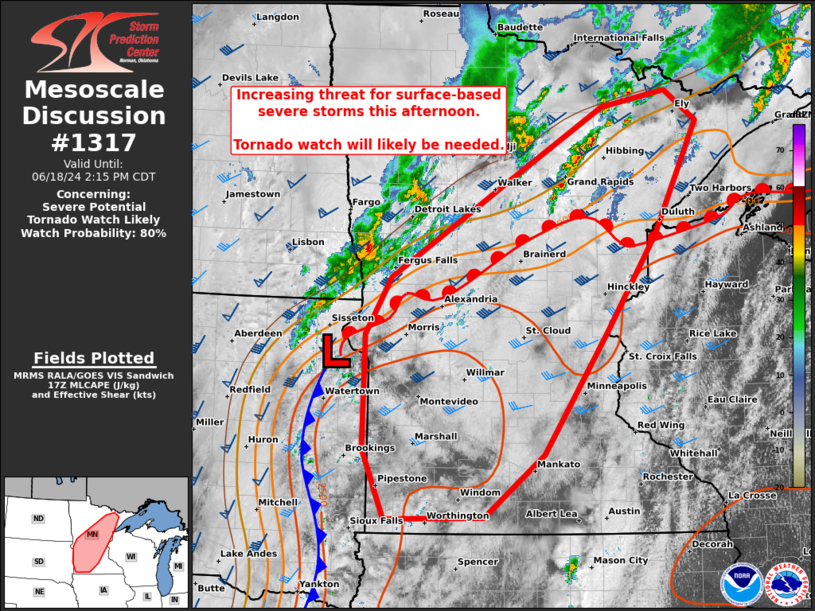
   Areas affected...most of MN

   Concerning...Severe potential...Tornado Watch likely

   Valid 181720Z - 181915Z

   Probability of Watch Issuance...80 percent

   SUMMARY...While initially elevated thunderstorms may pose an
   isolated severe hail threat, scattered surface-based storms will
   likely develop by mid to late afternoon from across most of
   Minnesota. All severe hazards are possible. A tornado watch will
   probably be needed by 19Z.

   DISCUSSION...17Z surface analysis placed a 997 mb cyclone near the
   northeast SD/west-central MN border with a warm front gradually
   advancing north into northern MN and a cold front arcing
   south-southwest into central NE. Initially elevated convection north
   of the front may pose some risk for isolated severe hail in the
   near-term. Latest SPC mesoanalysis indicates MLCIN has become weak
   with MLCAPE of 1500-2500 J/kg within the plume of pervasive low 70s
   boundary-layer dewpoints ahead of the cold front. Morning CAM
   guidance is insistent on scattered to eventually widespread
   convective development from northern MN building southward later
   this afternoon.

   While the mid to upper-level bulk shear will be modest with much of
   the stronger flow displaced west of the front, low-level hodographs
   will remain enlarged across the MN portion of the warm-moist sector.
   A rather messy convective mode is anticipated to evolve quickly
   given this wind profile. But with rich boundary-layer moisture and
   enhanced SRH, tornado potential is a concern from the warm frontal
   zone southward. A mix of outflow-dominated clusters with embedded
   and largely transient supercells is expected. These should yield
   potential for a few tornadoes, scattered wind gusts of 55-70 mph,
   and isolated large hail from 1-1.75 inches in diameter.

   ..Grams/Gleason.. 06/18/2024

   ...Please see www.spc.noaa.gov for graphic product...

   ATTN...WFO...DLH...MPX...FGF...FSD...ABR...

   LAT...LON   45579650 46179613 47179439 47959296 48119199 47809152
               46619217 45619290 44329384 43669474 43649620 44379653
               45579650
|
|
|
Top/All Mesoscale Discussions/Forecast Products/Home |
|


