| Mesoscale Discussion 1316 | |
| < Previous MD | |

|
|
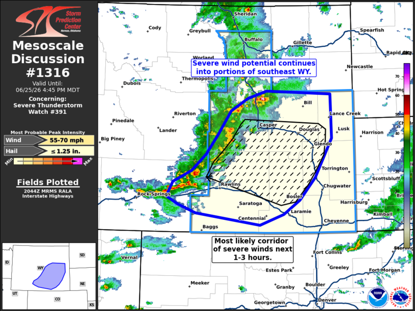
Mesoscale Discussion 1316 NWS Storm Prediction Center Norman OK 0346 PM CDT Thu Jun 25 2026 Areas affected...Central to southeast Wyoming Concerning...Severe Thunderstorm Watch 391... Valid 252046Z - 252245Z The severe weather threat for Severe Thunderstorm Watch 391 continues. SUMMARY...The potential for severe winds will continue into southeast Wyoming over the next few hours. Wind gusts between 60-70 mph appear possible. DISCUSSION...A loosely organized MCS continues to push east/southeast across central WY and has a history of producing wind gusts mostly between 35-55 mph. Over the past half hour, GOES IR imagery has shown steadily cooling cloud-top temperatures, implying a slow strengthening trend as the downstream air mass continues to warm and destabilize. Consequently, outflow wind speeds with the MCS may increase into the 60-70 mph range over the next couple of hours as the band moves into southeast WY. Based on recent velocity imagery, downstream low-level lapse rates, and time-lagged HRRR/RRFS ensembles, the greatest wind threat will most likely emerge between the I-80 to I-25 corridors over the next 1-2 hours before the MCS begins to push into a cooler, more stable air mass in place along the WY/NE border. ..Moore.. 06/25/2026 ...Please see www.spc.noaa.gov for graphic product... ATTN...WFO...CYS...RIW... LAT...LON 41130628 41330780 41490822 41620849 41880834 42090791 42380756 42730727 43150697 43370658 43490612 43440459 42650458 41970498 41570535 41310573 41130628 MOST PROBABLE PEAK WIND GUST...55-70 MPH MOST PROBABLE PEAK HAIL SIZE...UP TO 1.25 IN |
|
|
Top/All Mesoscale Discussions/Forecast Products/Home |
|
Source link