| Mesoscale Discussion 131 | |
| < Previous MD | |

|
|
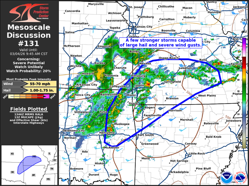
   Mesoscale Discussion 0131
   NWS Storm Prediction Center Norman OK
   0749 AM CST Wed Mar 04 2026

   Areas affected...Northeast Oklahoma into southern Missouri and
   northwest Arkansas

   Concerning...Severe potential...Watch unlikely

   Valid 041349Z - 041545Z

   Probability of Watch Issuance...20 percent

   SUMMARY...A few stronger storms are capable of large hail and severe
   wind gusts this morning.

   DISCUSSION...Storm coverage has increased across northeast Oklahoma
   and southwest Missouri this morning in close proximity to a
   shortwave trough moving across southeast Kansas and northern
   Oklahoma. The elevated instability environment southwest of where
   these storms are forming was well sampled by the OUN 12Z RAOB.
   MUCAPE in excess of 2000 J/kg and mid-level lapse rates around 8 to
   8.5 C/km were sampled. The SGF RAOB sampled around 1300 J/kg MUCAPE
   which may be more representative of the environment these storms
   have developed within. This thermodynamic environment combined with
   stronger shear farther northeast (~55 knots 0-6km per INX VWP) will
   support the potential for mostly elevated supercells capable of
   large hail and perhaps severe wind gusts. This threat will likely
   persist for a few hours this morning as storms move along and north
   of the surface boundary.

   ..Bentley/Gleason.. 03/04/2026

   ...Please see www.spc.noaa.gov for graphic product...

   ATTN...WFO...LSX...LZK...SGF...TSA...ICT...

   LAT...LON   36259565 37009514 37589444 37869419 38019375 38059326
               38049222 37909144 37639092 37219082 36849192 36289309
               35759399 35069523 35059545 35189574 36259565

   MOST PROBABLE PEAK WIND GUST...55-70 MPH
   MOST PROBABLE PEAK HAIL SIZE...1.00-1.75 IN
|
|
|
Top/All Mesoscale Discussions/Forecast Products/Home |
|
Source link