|
|
| Mesoscale Discussion 1305 | |
| < Previous MD | |

|
|
   Mesoscale Discussion 1305
   NWS Storm Prediction Center Norman OK
   0306 PM CDT Mon Jun 17 2024

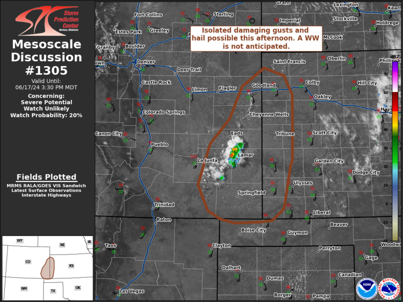
   Areas affected...parts of eastern Colorado and western Kansas

   Concerning...Severe potential...Watch unlikely

   Valid 172006Z - 172130Z

   Probability of Watch Issuance...20 percent

   SUMMARY...Isolated to widely scattered high-based convection that
   has recently evolved may persist with a threat for isolated damaging
   gusts and/or hail this afternoon. However, convective evolution and
   the spatial extent of any severe risk is uncertain.

   DISCUSSION...As of 20 UTC, regional radar and satellite data showed
   high-based convection has evolved across southeastern CO in the last
   hour. Likely driven by strong diurnal heating and the approach of a
   subtle shortwave trough, and modest ascent near a dryline will
   likely allow for continued convective development. Although
   high-based (with surface dewpoints only in the 40s-50s F) around
   1000 J/kg of MLCAPE (increasing with eastward extent) may be
   sufficient to support a few stronger updrafts, especially if storms
   move into deeper moisture farther north and east. Model soundings
   show very deep surface mixed layers with LCL heights in excess of
   2000 m. Given the steep low-level lapse rates, any sustained storms
   are likely to develop strong evaporative downdrafts with damaging
   gust potential. Isolated hail may also be possible with any of the
   more sustained updrafts given effective shear around 25-30 kt.

   While there remains some uncertainty on storm longevity with the
   marginal surface moisture, at least a few stronger updrafts may
   persist this afternoon, and potentially move into areas with greater
   buoyancy farther east. Some risk for damaging winds and hail is
   possible with any sustained storms as indicated by recent HRRR runs.
   Given this, convective trends will continue to be monitored though a
   WW appears unlikely at this time.

   ..Lyons/Halbert/Gleason.. 06/17/2024

   ...Please see www.spc.noaa.gov for graphic product...

   ATTN...WFO...DDC...GLD...AMA...PUB...

   LAT...LON   37920139 37170154 36970180 36930207 36910264 36990298
               37130326 37610350 38350323 38790278 39380250 39720199
               39580152 39230134 38710134 38050135 37920139
|
|
|
Top/All Mesoscale Discussions/Forecast Products/Home |
|


