| Mesoscale Discussion 1304 | |
| < Previous MD | |

|
|
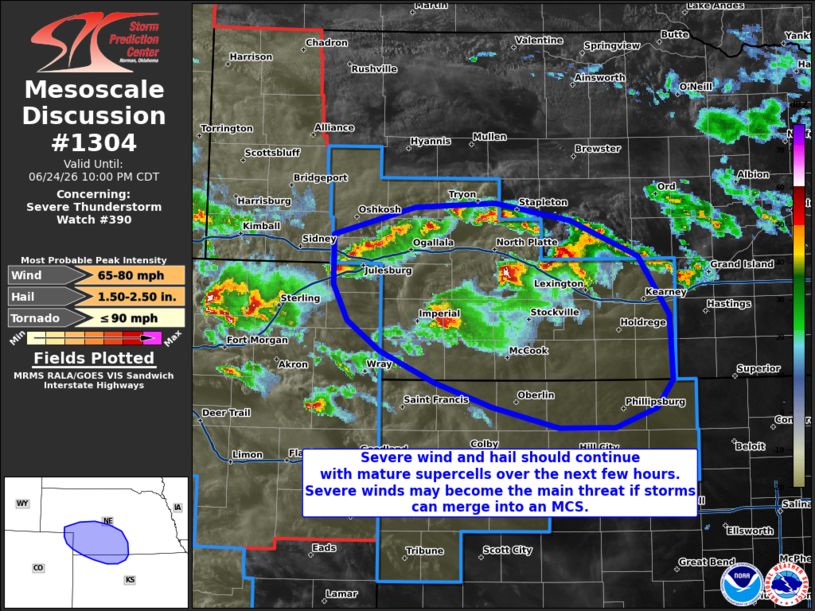
Mesoscale Discussion 1304 NWS Storm Prediction Center Norman OK 0858 PM CDT Wed Jun 24 2026 Areas affected...portions of extreme northeastern Colorado into southwestern Nebraska and far northwestern Kansas Concerning...Severe Thunderstorm Watch 390... Valid 250158Z - 250300Z The severe weather threat for Severe Thunderstorm Watch 390 continues. SUMMARY...Severe wind and hail may continue with ongoing supercells. There is some indication of upscale growth into an MCS. Should this occur, then severe winds will become the predominant threat. DISCUSSION...MRMS mosaic radar data depicts multiple supercells progressing southward across western/central NE. Some of these storms have a history of severe wind and hail, with the latest mosaic MRMS MESH data showing multiple storms potentially producing 2+ inch diameter hail. Based on the last few runs of the HRRR and WoFS ensemble guidance, it appears that supercells will persist for at least a few more hours, accompanied by both severe hail and gusts. However, as also shown by the HRRR/WoFS, cold pool mergers with ongoing supercells may encourage upscale growth into an MCS in a few hours, with severe gusts becoming the main threat. Regardless of storm morphology and evolution, the 00Z mesoanalysis shows 1500+ J/kg MLCAPE and 50+ kts of effective bulk shear preceding the ongoing storms, so the severe wind and hail should persist in some form through the evening hours. ..Squitieri.. 06/25/2026 ...Please see www.spc.noaa.gov for graphic product... ATTN...WFO...GID...LBF...GLD...BOU... LAT...LON 41240259 41480166 41520076 41379990 41079914 40569879 40009876 39759894 39589940 39590003 39770079 39970143 40240206 40500242 40820258 41240259 MOST PROBABLE PEAK TORNADO INTENSITY...UP TO 90 MPH MOST PROBABLE PEAK WIND GUST...65-80 MPH MOST PROBABLE PEAK HAIL SIZE...1.50-2.50 IN |
|
|
Top/All Mesoscale Discussions/Forecast Products/Home |
|
Source link