| Mesoscale Discussion 1297 | |
| < Previous MD | |

|
|
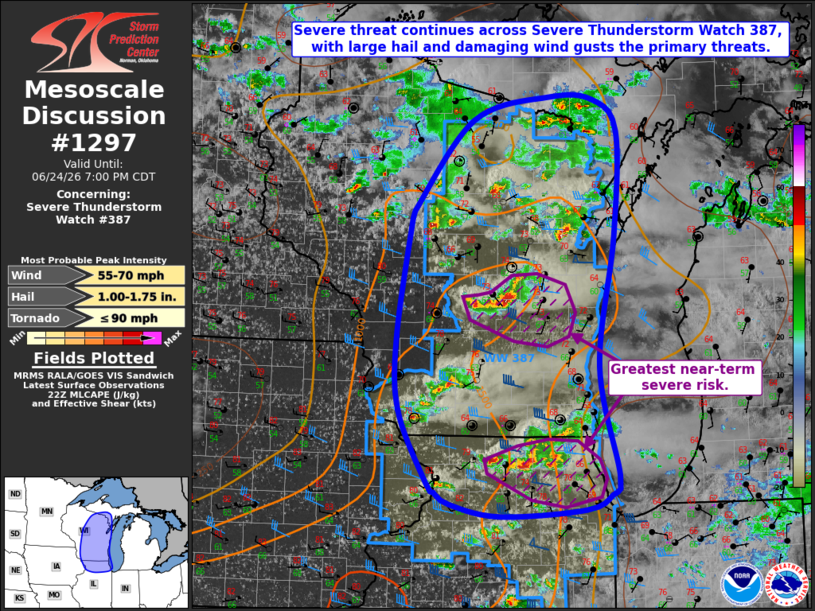
Mesoscale Discussion 1297 NWS Storm Prediction Center Norman OK 0528 PM CDT Wed Jun 24 2026 Areas affected...portions of the western Great Lakes region Concerning...Severe Thunderstorm Watch 387... Valid 242228Z - 250000Z The severe weather threat for Severe Thunderstorm Watch 387 continues. SUMMARY...The risk for primarily large hail and damaging wind gusts continues across Severe Thunderstorm Watch 387. A brief tornado or two also remain possible. DISCUSSION...Regional radar imagery depicts widely scattered thunderstorms ongoing from northern Wisconsin southward into northern Illinois, with a mixed mode of supercells and clusters noted as of 2220 UTC. This convection has produced several reports of large hail (up to 1.25" in diameter) over the past 1-2 hours, with sporadic reports of wind damage and brief funnel clouds also received. This risk will persist over the next couple of hours as convection evolves east-southeastward towards Lake Michigan. The greatest severe potential appears to exist across the southern half of the Severe Thunderstorm Watch area, where greater buoyancy exists within the hail growth zone, which may promote an instance or two of large hail approaching golf ball size. Modestly steeper low-level lapse rates will also continue to promote the potential for damaging wind gusts. Lastly, a brief tornado or two cannot be ruled out, especially where low-level SRH is modestly enhanced in the vicinity of the lake breeze. ..Chalmers.. 06/24/2026 ...Please see www.spc.noaa.gov for graphic product... ATTN...WFO...MQT...GRB...LOT...MKX...DVN...DLH...ARX... LAT...LON 41858754 41708792 41628917 41758991 41889014 41989025 42779068 43559071 44849050 44929046 45908958 46168843 46138778 45798742 44658746 43248770 42078742 41858754 MOST PROBABLE PEAK TORNADO INTENSITY...UP TO 90 MPH MOST PROBABLE PEAK WIND GUST...55-70 MPH MOST PROBABLE PEAK HAIL SIZE...1.00-1.75 IN |
|
|
Top/All Mesoscale Discussions/Forecast Products/Home |
|
Source link