| Mesoscale Discussion 1284 | |
| < Previous MD | |

|
|
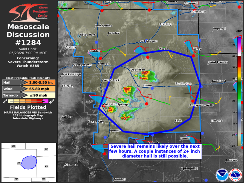
Mesoscale Discussion 1284 NWS Storm Prediction Center Norman OK 0658 PM CDT Tue Jun 23 2026 Areas affected...portions of central into eastern Colorado Concerning...Severe Thunderstorm Watch 385... Valid 232358Z - 240100Z The severe weather threat for Severe Thunderstorm Watch 385 continues. SUMMARY...Severe hail will remain a concern with ongoing supercells. A couple of severe gusts could occur as well. DISCUSSION...Splitting supercells have developed east of I-25, and are progressing eastward. Regional VADs and 23Z mesoanalysis depict primarily straight, elongated hodographs over central and eastern CO, suggesting that severe hail will remain likely with splitting supercells given 2500+ J/kg MLCAPE. Given 60 kts of effective bulk shear comprising the straight hodographs, 2.0-3.5 inch diameter hail remains possible, especially with left-splitting supercells. A couple of severe gusts or a tornado may also occur. ..Squitieri.. 06/23/2026 ...Please see www.spc.noaa.gov for graphic product... ATTN...WFO...GLD...PUB...BOU... LAT...LON 38780491 39660449 40010372 40100297 39930228 39300202 38570232 38310283 38220350 38280422 38780491 MOST PROBABLE PEAK TORNADO INTENSITY...UP TO 90 MPH MOST PROBABLE PEAK WIND GUST...65-80 MPH MOST PROBABLE PEAK HAIL SIZE...2.00-3.50 IN |
|
|
Top/All Mesoscale Discussions/Forecast Products/Home |
|
Source link