| Mesoscale Discussion 1281 | |
| < Previous MD | |

|
|
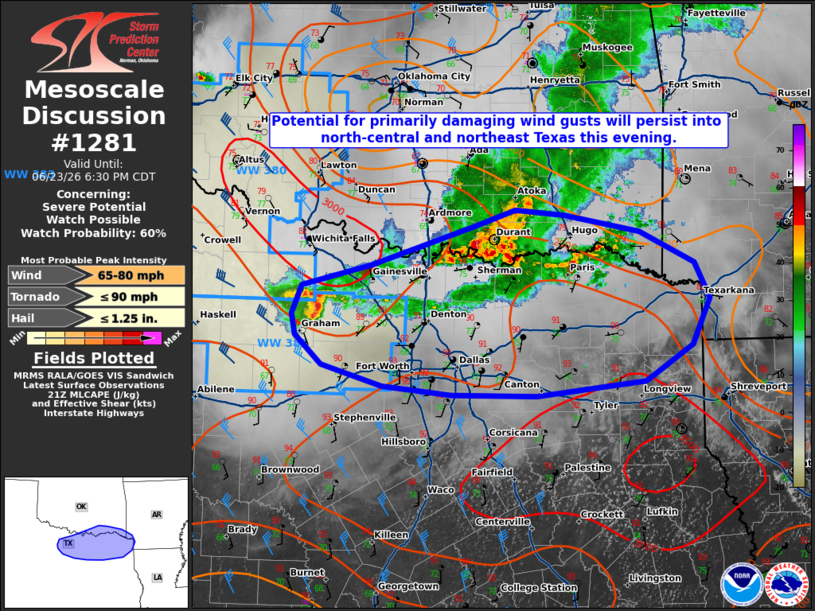
   Mesoscale Discussion 1281
   NWS Storm Prediction Center Norman OK
   0458 PM CDT Tue Jun 23 2026

   Areas affected...portions of the Red River Valley into north-central
   and northeast Texas

   Concerning...Severe potential...Watch possible

   Valid 232158Z - 232330Z

   Probability of Watch Issuance...60 percent

   SUMMARY...Potential for primarily damaging wind gusts will continue
   into portions of north-central and northeast Texas this evening. A
   new Severe Thunderstorm Watch and/or local watch extensions may be
   needed.

   DISCUSSION...Two persistent convective clusters remain ongoing along
   and south of the Red River Valley as of 2155 UTC. Modest synoptic
   support associated with a subtle mid-level perturbation/MCV may
   support continued maintenance of these clusters as they encounter
   greater buoyancy (2500+ J/kg MLCAPE) south of the Red River. This
   may promote some intensification of ongoing thunderstorms in the
   near-term across portions of north-central and northeast Texas. A
   new Severe Thunderstorm Watch and/or local watch extensions may be
   needed shortly to cover this potential.

   ..Chalmers/Smith.. 06/23/2026

   ...Please see www.spc.noaa.gov for graphic product...

   ATTN...WFO...SHV...TSA...FWD...OUN...

   LAT...LON   33539857 33739778 34129659 34269615 34229559 34059474
               33759411 33419395 32979415 32649467 32499590 32519686
               32599765 32799833 33069863 33279868 33539857

   MOST PROBABLE PEAK TORNADO INTENSITY...UP TO 90 MPH
   MOST PROBABLE PEAK WIND GUST...65-80 MPH
   MOST PROBABLE PEAK HAIL SIZE...UP TO 1.25 IN
|
|
|
Top/All Mesoscale Discussions/Forecast Products/Home |
|
Source link