| Mesoscale Discussion 1274 | |
| < Previous MD | |

|
|
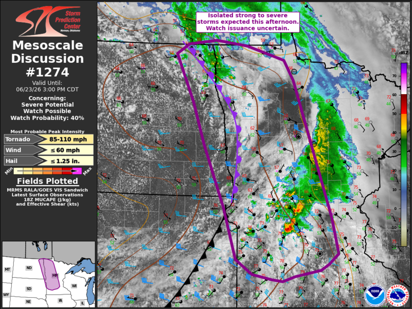
   Mesoscale Discussion 1274
   NWS Storm Prediction Center Norman OK
   0103 PM CDT Tue Jun 23 2026

   Areas affected...far eastern North Dakota into parts of Minnesota

   Concerning...Severe potential...Watch possible

   Valid 231803Z - 232000Z

   Probability of Watch Issuance...40 percent

   SUMMARY...Isolated thunderstorm development expected the next few
   hours from far eastern North Dakota into parts of Minnesota. The
   strongest storms may produce gusty winds, hail, and a tornado or
   two. Watch issuance is uncertain.

   DISCUSSION...In the wake of morning showers and thunderstorms across
   central/northern MN, additional storm development is expected within
   a modestly destabilizing airmass. A cluster of storms across central
   MN how shown some signs of intensification over the past 30 minutes.
   This activity is occurring within a zone of strong low-level
   convergence ahead of a surface cold front and near/south of an
   occluding front extending north/northwest across northern MN into
   eastern ND.

   Modest midlevel lapse rates and weak boundary layer moisture will
   support generally 1000 J/kg MLCAPE or less across the region.
   However, stronger mid/upper level westerly flow will foster
   effective shear magnitudes near 25-35 kt, fostering at least
   transient organized cells. The strongest storms will be capable of
   hail as large as 1-1.25 inches and gusty winds (where stronger
   heating occurs). A tornado or two also is possible within backed
   low-level flow ahead of the surface boundary and on the eastern
   flank of a surface low where mildly enhanced 0-1 km SRH is present.
   Convection should gradually increase in coverage with northward
   extent into the afternoon. Given the overall modest environmental
   parameter space, the need for a watch is uncertain as the overall
   threat may remain sparse/transient due to a lack of higher quality
   boundary layer moisture and stronger instability. Trends will
   continue to be monitored.

   ..Leitman/Guyer.. 06/23/2026

   ...Please see www.spc.noaa.gov for graphic product...

   ATTN...WFO...DLH...MPX...FGF...FSD...ABR...

   LAT...LON   44749354 44549382 44419405 44309479 44209515 44249546
               44349603 44659649 45719685 46989744 47839778 48809831
               49009793 49099709 48979617 48699506 48289478 45499372
               44749354

   MOST PROBABLE PEAK TORNADO INTENSITY...85-110 MPH
   MOST PROBABLE PEAK WIND GUST...UP TO 60 MPH
   MOST PROBABLE PEAK HAIL SIZE...UP TO 1.25 IN
|
|
|
Top/All Mesoscale Discussions/Forecast Products/Home |
|
Source link