| Mesoscale Discussion 1273 | |
| < Previous MD Next MD > | |

|
|
Mesoscale Discussion 1273
NWS Storm Prediction Center Norman OK
1247 PM CDT Tue Jun 23 2026
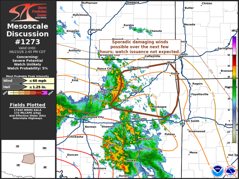
Areas affected...Northeast Oklahoma
Concerning...Severe potential...Watch unlikely
Valid 231747Z - 231945Z
Probability of Watch Issuance...5 percent
SUMMARY...A band of thunderstorms may produce sporadic wind damage
through the mid-afternoon hours. Given the marginal downstream
environment, watch issuance is not expected.
DISCUSSION...A semi-organized band of thunderstorms has emerged to
the northwest of the Tulsa, OK metro over the past hour with a
consolidated coldpool/outflow evident in nearby KINX imagery.
Although most wind reports thus far have been between 20-30 mph,
GOES IR imagery and lightning counts suggest that this band has been
slowly strengthening. Further downstream, widespread cloud cover and
cool outflow from prior convection is muting diurnal heating;
nonetheless, temperatures are warming into the mid/upper 70s with an
attendant increase in MLCAPE noted in recent mesoanalyses.
Consequently, further intensification of the line appears possible
in the next few hours and may support an increase in damaging wind
potential. VWP observations from KINX show a fairly modest kinematic
environment, which will likely act to modulate overall storm
intensity and preclude the need for watch issuance.
..Moore/Guyer.. 06/23/2026
...Please see www.spc.noaa.gov for graphic product...
ATTN...WFO...SGF...TSA...OUN...
LAT...LON 35859664 36099643 36329632 36479633 36629637 36719624
36929480 36679456 36469453 36209451 35839459 35629474
35529498 35749653 35859664
MOST PROBABLE PEAK WIND GUST...UP TO 60 MPH
MOST PROBABLE PEAK HAIL SIZE...UP TO 1.25 IN
|
|
|
Top/All Mesoscale Discussions/Forecast Products/Home |
|
Source link