| Mesoscale Discussion 127 | |
| < Previous MD | |

|
|
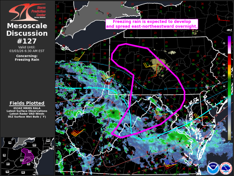
   Mesoscale Discussion 0127
   NWS Storm Prediction Center Norman OK
   1136 PM CST Mon Mar 02 2026

   Areas affected...Parts of western/central PA...western/northern
   MD...eastern WV...northern VA

   Concerning...Freezing rain

   Valid 030536Z - 031130Z

   SUMMARY...Freezing rain is expected to develop and spread
   east-northeastward overnight.

   DISCUSSION...A large area of light precipitation is ongoing late
   this evening across parts of OH/WV/VA. A veering low-level wind
   profile and strengthening flow in the lowest 2 km AGL (as observed
   in the KRLX VWP) are indicative of a low-level warm-advection regime
   that will sustain this area of precipitation as it spreads
   east-northeastward into the overnight. Precipitation will eventually
   spread into parts of western/central PA/MD, eastern WV, and northern
   VA that are currently below freezing, resulting in an increasing
   coverage of winter precipitation.

   Some sleet and/or light snow may fall at the onset of precipitation,
   especially where colder antecedent temperatures (20s F) are in place
   across parts of PA and northern MD. Otherwise, an increasingly
   prominent warm nose in the 900-800 mb layer should allow for
   development of freezing rain into the overnight hours as
   precipitation spreads east-northeastward. Precipitation should
   generally remain rather light, though liquid-equivalent rates
   approaching 0.05 inches per 3 hours will support ice-accretion
   potential, especially in terrain-favored areas where colder
   temperatures and locally greater rates may persist. Southern and
   western portions of the MCD area may eventually warm above freezing
   overnight, but near/sub-freezing surface temperatures are expected
   to persist through dawn from central PA into northern VA/MD.

   ..Dean.. 03/03/2026

   ...Please see www.spc.noaa.gov for graphic product...

   ATTN...WFO...CTP...LWX...RNK...PBZ...RLX...CLE...

   LAT...LON   39177680 38547781 38187902 38007983 38168033 38418004
               38807975 39227943 40507923 40747966 40868004 41118040
               41348037 41678004 41747966 41577849 40377692 39837658
               39507660 39177680
|
|
|
Top/All Mesoscale Discussions/Forecast Products/Home |
|
Source link