|
|
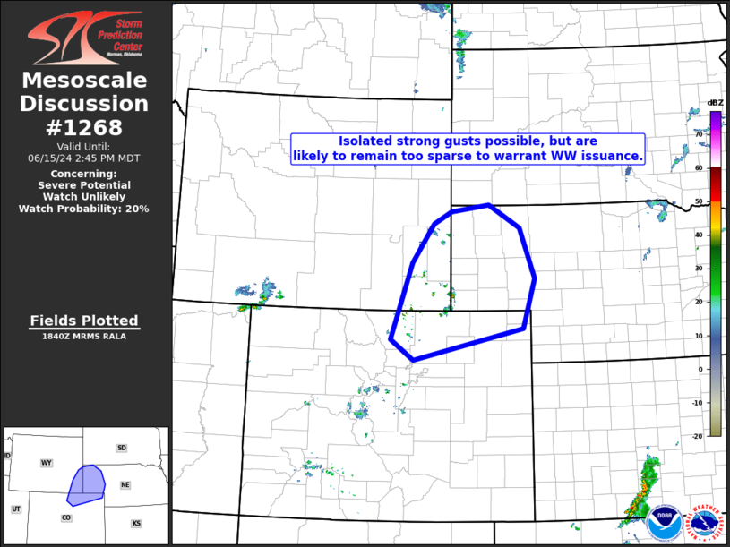
| Mesoscale Discussion 1268 | |
| < Previous MD | |

|
|
   Mesoscale Discussion 1268
   NWS Storm Prediction Center Norman OK
   0142 PM CDT Sat Jun 15 2024

   Areas affected...northeastern Colorado...southeastern Wyoming...and
   the Nebraska Panhandle

   Concerning...Severe potential...Watch unlikely

   Valid 151842Z - 152045Z

   Probability of Watch Issuance...20 percent

   SUMMARY...High-based storm development will continue -- initially
   over the higher terrain but spreading eastward with time.  A few
   strong gusts are possible, but isolated nature of this risk suggests
   that WW issuance will likely not be required.

   DISCUSSION...Daytime heating across the central High Plains region
   is supporting modest destabilization, and initiation of high-based
   convection -- most notably from southeastern Wyoming southward into
   the central Colorado Front Range.  The convection is developing
   above a deep mixed layer, where dewpoints are generally now observed
   in the 40s and 50s across the area.

   Flow aloft remains generally weak over the central High Plains, and
   CAPE limited, suggesting that storms should remain largely
   disorganized this afternoon.  However, given potential for
   evaporative cooling in the sub-cloud layer, a few enhanced gusts
   capable of producing wind damage will be locally possible across the
   area into this evening.

   ..Goss/Gleason.. 06/15/2024

   ...Please see www.spc.noaa.gov for graphic product...

   ATTN...WFO...LBF...UNR...BOU...CYS...

   LAT...LON   42880404 43000309 42570231 41610193 40650224 40050498
               40450555 41910502 42650447 42880404
|
|
|
Top/All Mesoscale Discussions/Forecast Products/Home |
|


