| Mesoscale Discussion 1246 | |
| < Previous MD Next MD > | |

|
|
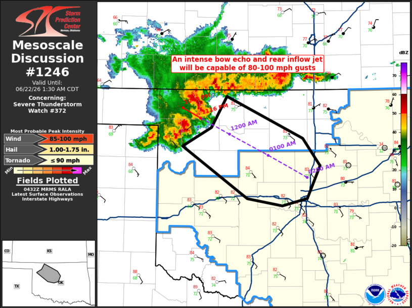
Mesoscale Discussion 1246 NWS Storm Prediction Center Norman OK 1134 PM CDT Sun Jun 21 2026 Areas affected...northwest into central OK Concerning...Severe Thunderstorm Watch 372... Valid 220434Z - 220630Z The severe weather threat for Severe Thunderstorm Watch 372 continues. SUMMARY...An intense bow echo and rear inflow jet will be capable of 80-100 mph gusts, potentially as far southeast as the OKC metro. DISCUSSION...Radar mosaic shows a mature and intense bow echo and associated rear inflow jet over northwest OK late this evening. The airmass ahead of this is very unstable with 3000-4000 J/kg MLCAPE. Ample mid to high-level northwesterly flow and a very moisture-rich boundary layer will favor further intensification and maintenance of this bow echo southeastward into central OK. Recent HRRR models runs are congruent with this overall convective evolution. Peak gusts of 80-100 mph are forecast with the bow echo. Mesovortices within the line will also focus intense wind swaths and perhaps yield a brief tornado or two. ..Smith.. 06/22/2026 ...Please see www.spc.noaa.gov for graphic product... ATTN...WFO...OUN... LAT...LON 35509847 36219958 36489909 36919883 36339754 35949724 35499747 35399789 35509847 MOST PROBABLE PEAK TORNADO INTENSITY...UP TO 90 MPH MOST PROBABLE PEAK WIND GUST...85-100 MPH MOST PROBABLE PEAK HAIL SIZE...1.00-1.75 IN |
|
|
Top/All Mesoscale Discussions/Forecast Products/Home |
|
Source link