| Mesoscale Discussion 1243 | |
| < Previous MD Next MD > | |
|
|
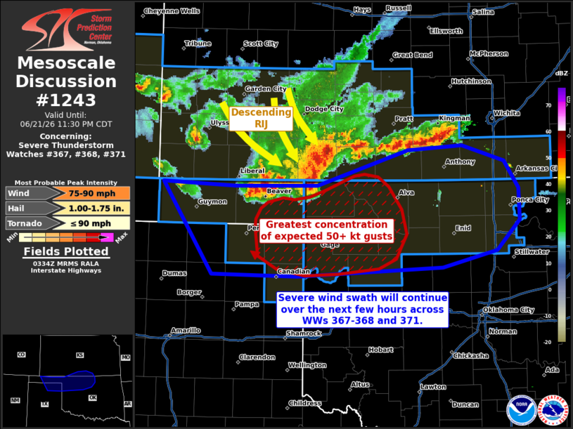
Mesoscale Discussion 1243 NWS Storm Prediction Center Norman OK 1036 PM CDT Sun Jun 21 2026 Areas affected...portions of southwestern Kansas...Oklahoma and Texas Panhandles...northwestern Oklahoma Concerning...Severe Thunderstorm Watch 367...368...371... Valid 220336Z - 220430Z The severe weather threat for Severe Thunderstorm Watch 367, 368, 371 continues. SUMMARY...Numerous additional 50+ kt convective gusts are expected with an approaching MCS over the next few hours. A few gusts could exceed 75 mph. DISCUSSION...A cold-pool-driven MCS, with a history of numerous measured 50+ kt gusts, continues to propagate southeast into a highly unstable/sheared airmass. KVNX inbound velocity data depicts a descending rear-inflow jet at the apex of a bowing structure embedded within the MCS, which should serve as the impetus for numerous additional 50+ kt gusts over the next few hours, particularly over northwestern OK. Given the highly organized MCS structure interacting with such a favorably destabilized/sheared environment, a few gusts may exceed 75 mph. ..Squitieri.. 06/22/2026 ...Please see www.spc.noaa.gov for graphic product... ATTN...WFO...TSA...ICT...OUN...DDC...AMA... LAT...LON 36960196 36920096 36939980 37349854 37399777 37219718 36909699 36549697 36199730 36019805 35949936 35900008 35930127 36960196 MOST PROBABLE PEAK TORNADO INTENSITY...UP TO 90 MPH MOST PROBABLE PEAK WIND GUST...75-90 MPH MOST PROBABLE PEAK HAIL SIZE...1.00-1.75 IN |
|
|
Top/All Mesoscale Discussions/Forecast Products/Home |
|
Source link