| Mesoscale Discussion 1232 | |
| < Previous MD | |

|
|
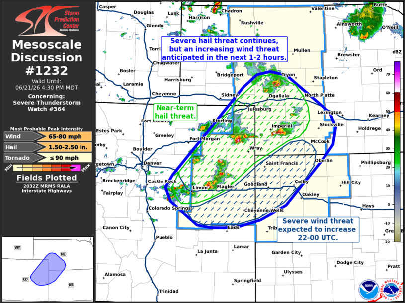
Mesoscale Discussion 1232 NWS Storm Prediction Center Norman OK 0333 PM CDT Sun Jun 21 2026 Areas affected...Eastern Colorado...southwest Nebraska...and northwest Kansas Concerning...Severe Thunderstorm Watch 364... Valid 212033Z - 212230Z The severe weather threat for Severe Thunderstorm Watch 364 continues. SUMMARY...The threat for large hail continues across eastern Colorado and into southwest Nebraska. However, upscale growth into an MCS is anticipated through early evening with an attendant uptick in severe wind potential across northwest Kansas. DISCUSSION...Multiple instances of 1.0 to 1.75 inch hail have been noted across the central High Plains over the past couple of hours as loosely organized splitting supercells continue to develop and mature. Based on recent radar trends, these cells are likely sufficiently spaced to maintain mostly discrete storm modes for the next hour or two, which will maintain the threat for large hail - especially along/near the eastern CO border where thermodynamic conditions are most favorable for very large (2 inch) hail. Beyond the next couple of hours, the combination of deviant storm motions and colliding outflow boundaries (at least one of which is already noted in reflectivity data from KFTG) will promote storm interactions and gradual upscale growth into one or more clusters. As this occurs, cold pool amalgamation/intensification within an environment featuring steep low-level lapse rates should promote increasing potential for severe wind gusts, including occasional gusts upwards of 75 mph. Per time-lagged HRRR/RRFS ensembles, this transition appears most likely to occur across east-central CO and into northwest KS during the 22-00 UTC time frame. ..Moore.. 06/21/2026 ...Please see www.spc.noaa.gov for graphic product... ATTN...WFO...GID...LBF...GLD...PUB...BOU...CYS... LAT...LON 39040422 39320437 39570420 41360235 41620200 41670164 41610122 40830006 40539992 40200000 39910028 38990125 38690191 38570245 38530283 38530318 38590353 39040422 MOST PROBABLE PEAK TORNADO INTENSITY...UP TO 90 MPH MOST PROBABLE PEAK WIND GUST...65-80 MPH MOST PROBABLE PEAK HAIL SIZE...1.50-2.50 IN |
|
|
Top/All Mesoscale Discussions/Forecast Products/Home |
|
Source link