| Mesoscale Discussion 123 | |
| < Previous MD | |

|
|
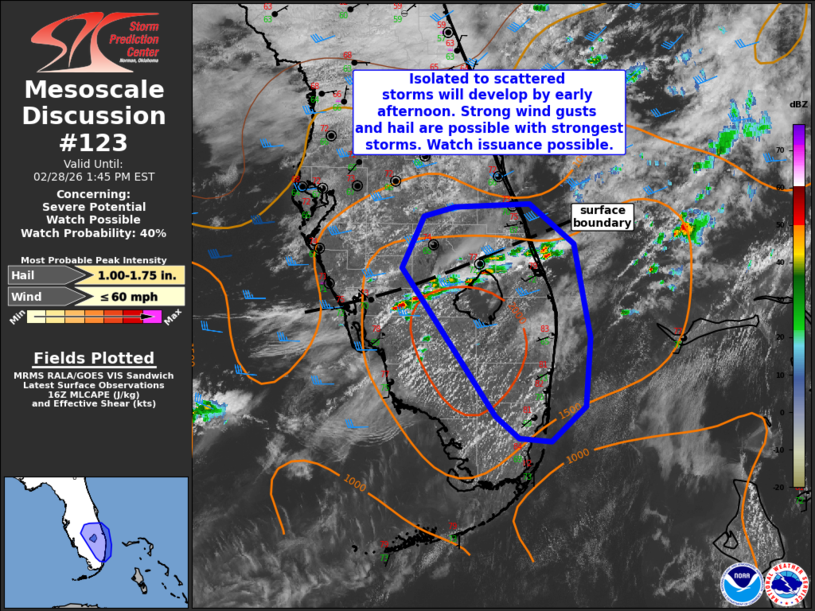
   Mesoscale Discussion 0123
   NWS Storm Prediction Center Norman OK
   1046 AM CST Sat Feb 28 2026

   Areas affected...portions of the central/southern Florida Peninsula

   Concerning...Severe potential...Watch possible

   Valid 281646Z - 281845Z

   Probability of Watch Issuance...40 percent

   SUMMARY...Thunderstorm activity will increase over the next couple
   of hours over eastern portions of the central/southern Florida
   Peninsula. Some of these storms could become strong to severe this
   afternoon, posing a risk for locally damaging wind gusts and
   isolated large hail.

   DISCUSSION...Convection is developing along a surface
   boundary/residual outflow oriented from Charlotte to St. Lucie
   counties. This activity is developing in a moist environment with
   dewpoints in the 69-73 F range. Temperatures have already warmed
   into the upper 70s/low 80s F at midday. With additional heating and
   increasing large-scale ascent overspreading the region this
   afternoon, convection will intensify and increase in coverage over
   the next couple of hours, both along the surface outflow and near
   the east coast sea breeze.

   MLCAPE values have already increased to around 1500-2000 J/kg and
   effective shear will support some updraft organization despite weak
   low-level flow. Midlevel lapse rates are forecast to remain poor,
   but given sufficient instability and shear, some stronger storms
   could produce hail to around 1.5 inches. Steepened low-level lapse
   rates and storm interactions also could support locally strong wind
   gusts. The best area for severe storms is somewhat limited
   spatially, near St. Lucie to Broward Counties, and the need for a
   watch is uncertain, though trends will be monitored over the next
   couple of hours.

   ..Leitman/Smith.. 02/28/2026

   ...Please see www.spc.noaa.gov for graphic product...

   ATTN...WFO...MFL...MLB...TBW...

   LAT...LON   27238166 27728144 27808110 27838032 27467984 26567967
               25917973 25588008 25618042 25828067 27238166

   MOST PROBABLE PEAK WIND GUST...UP TO 60 MPH
   MOST PROBABLE PEAK HAIL SIZE...1.00-1.75 IN
|
|
|
Top/All Mesoscale Discussions/Forecast Products/Home |
|
Source link