| Mesoscale Discussion 1227 | |
| < Previous MD | |

|
|
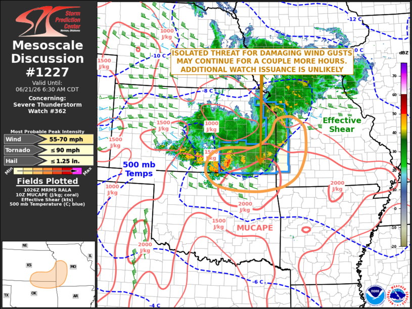
Mesoscale Discussion 1227 NWS Storm Prediction Center Norman OK 0527 AM CDT Sun Jun 21 2026 Areas affected...Southeast Kansas...Northeast Oklahoma...Southwest Missouri Concerning...Severe Thunderstorm Watch 362... Valid 211027Z - 211130Z The severe weather threat for Severe Thunderstorm Watch 362 continues. SUMMARY...An isolated threat for damaging wind gusts will be possible over the next couple of hours from southeast Kansas into northeast Oklahoma and southwest Missouri. The threat should be too isolated for additional weather watch issuance. DISCUSSION...An MCS is ongoing from Kansas into far western Missouri, on the northern side of an unstable airmass. The MCS is being supported by strong warm advection and large-scale ascent associated with a shortwave trough moving through the region. The strongest part of the MCS is in southeast Kansas, where the RAP estimates that MUCAPE is near 2000 J/kg and effective shear is around 40 knots. This will be sufficient for an isolated severe threat early this morning. The potential for severe wind gusts should be maximized along the leading edge of any short bowing line segment that can remain organized and surface-based. The severe threat should become more isolated as inhibition continues to increase. ..Broyles.. 06/21/2026 ...Please see www.spc.noaa.gov for graphic product... ATTN...WFO...SGF...EAX...TSA...TOP...ICT...OUN... LAT...LON 38879460 38459482 38129515 37919567 37919631 37879698 37719741 37469766 36999774 36569728 36389648 36339545 36419476 36569417 36949363 37649330 38389326 38749340 38989382 38999421 38879460 MOST PROBABLE PEAK TORNADO INTENSITY...UP TO 90 MPH MOST PROBABLE PEAK WIND GUST...55-70 MPH MOST PROBABLE PEAK HAIL SIZE...UP TO 1.25 IN |
|
|
Top/All Mesoscale Discussions/Forecast Products/Home |
|
Source link