| Mesoscale Discussion 1225 | |
| < Previous MD | |

|
|
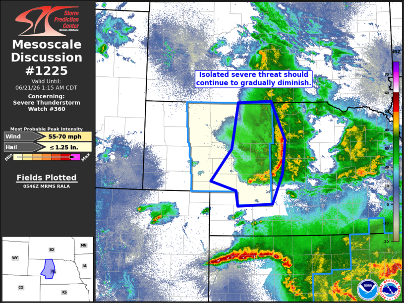
Mesoscale Discussion 1225 NWS Storm Prediction Center Norman OK 1248 AM CDT Sun Jun 21 2026 Areas affected...portions of the Nebraska Sandhills Concerning...Severe Thunderstorm Watch 360... Valid 210548Z - 210615Z CORRECTED FOR GRAPHIC The severe weather threat for Severe Thunderstorm Watch 360 continues. SUMMARY...Thunderstorms continue moving east across portions of north-central Nebraska this evening. Modest instability and strong shear should maintain the MCS structure, although weak low-level lapse rates should keep any severe threat rather isolated. DISCUSSION...A north-south linear MCS has organized across portions of north-central Nebraska this evening and will continue eastward into the morning hours. The overall environment remains kinematically favorable for thunderstorm organization (effective layer shear greater than 50 knots), although the thermodynamic environment remains modest at best with between 500 to 1000 J/kg of MUCAPE along the line of storms. Additionally, low-level lapse rates continue to weaken, with 0-3 kilometer lapse rates objectively analyzed to be around 3 C/km. Thus, despite the linear MCS's organization, the elevated nature of the individual thunderstorms and the weak low-level lapse rates should limit any severe wind potential to being isolated/sporadic in nature. ..Marsh.. 06/21/2026 ...Please see www.spc.noaa.gov for graphic product... ATTN...WFO...GID...LBF...UNR... LAT...LON 41230203 41960140 42990121 43030021 42169979 41409988 40720019 40670121 41020128 41230203 MOST PROBABLE PEAK WIND GUST...55-70 MPH MOST PROBABLE PEAK HAIL SIZE...UP TO 1.25 IN |
|
|
Top/All Mesoscale Discussions/Forecast Products/Home |
|
Source link