| Mesoscale Discussion 1219 | |
| < Previous MD | |

|
|
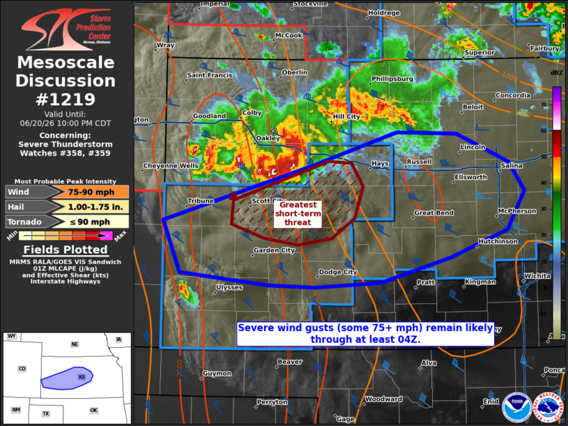
Mesoscale Discussion 1219 NWS Storm Prediction Center Norman OK 0829 PM CDT Sat Jun 20 2026 Areas affected...portions of western into central Kansas Concerning...Severe Thunderstorm Watch 358...359... Valid 210129Z - 210300Z The severe weather threat for Severe Thunderstorm Watch 358, 359 continues. SUMMARY...Severe wind gusts exceeding 75 mph will remain a concern over the next few hours with a south-southeastward progressing MCS. DISCUSSION...A cold-pool-driven MCS continues to propagate to the east-southeast across western KS, with a history of 60-100 mph wind gusts. The DDC 00Z observed sounding, which is well ahead of the MCS, depicts an elongated hodograph and over 50 kts of effective bulk shear, which should aid ongoing storms to sustain a bowing MCS structure. However, while the 00Z observed sounding shows 8.5+ C/km mid-level lapse rates preceding the MCS, a relatively neutral/slightly stable 850-700 mb layer may eventually encourage a weakening trend in the next few hours given nocturnal cooling. This trend is also suggested by the latest HRRR deterministic and WoFs ensemble runs. Until then though, severe gusts (a few potentially exceeding 75 mph) remain possible through at least 04Z. ..Squitieri.. 06/21/2026 ...Please see www.spc.noaa.gov for graphic product... ATTN...WFO...TOP...ICT...GID...DDC...GLD...PUB... LAT...LON 38310205 38900009 39259896 39229818 38929748 38629729 38239752 37949826 37699918 37630004 37650065 37780181 38310205 MOST PROBABLE PEAK TORNADO INTENSITY...UP TO 90 MPH MOST PROBABLE PEAK WIND GUST...75-90 MPH MOST PROBABLE PEAK HAIL SIZE...1.00-1.75 IN |
|
|
Top/All Mesoscale Discussions/Forecast Products/Home |
|
Source link