| Mesoscale Discussion 1217 | |
| < Previous MD | |

|
|
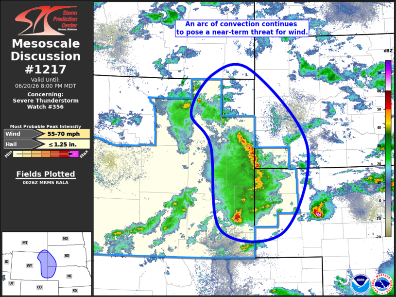
Mesoscale Discussion 1217 NWS Storm Prediction Center Norman OK 0727 PM CDT Sat Jun 20 2026 Areas affected...eastern Wyoming...western Nebraska Panhandle...southwest South Dakota...and far southeast Montana Concerning...Severe Thunderstorm Watch 356... Valid 210027Z - 210200Z The severe weather threat for Severe Thunderstorm Watch 356 continues. SUMMARY...Thunderstorms with a history of measured severe winds will weaken as the move northeast this evening. Although a few severe wind gusts will be possible in the near term, the overall wind threat will weaken with time. A new watch is currently not anticipated. DISCUSSION...An arc of convection across eastern Wyoming continues to fan out as it moves east across the High Plains. These storms have had a history of producing significant winds, with multiple reports of winds in excess of 80 mph across Converse and Wright counties. The non-convectively modified airmass across eastern Wyoming features steep low-to-mid-level lapse rates that have supported downward momentum transfer and the subsequent strong winds as convection moves into them. However, as the storms move farther north and east, the airmass becomes increasingly unfavorable for severe gusts as instability quickly decreases and low-level lapse rates considerably weaken. Given the ongoing storms and their recent history, the potential for isolated severe wind gusts will continue in the near term. However, longer-term, the increasingly unfavorable environment should limit downward momentum transfer and the overall severe potential. As such, a downstream severe thunderstorm watch is currently not anticipated. ..Marsh.. 06/21/2026 ...Please see www.spc.noaa.gov for graphic product... ATTN...WFO...LBF...UNR...CYS...BYZ...RIW... LAT...LON 41600506 43500540 44230602 45110534 45200415 43490242 41570316 41600506 MOST PROBABLE PEAK WIND GUST...55-70 MPH MOST PROBABLE PEAK HAIL SIZE...UP TO 1.25 IN |
|
|
Top/All Mesoscale Discussions/Forecast Products/Home |
|
Source link