|
|
| Mesoscale Discussion 1216 | |
| < Previous MD | |

|
|
   Mesoscale Discussion 1216
   NWS Storm Prediction Center Norman OK
   0235 PM CDT Sun Jun 09 2024

   Areas affected...Southeast New Mexico into western Texas and
   southern Oklahoma

   Concerning...Severe potential...Watch unlikely

   Valid 091935Z - 092130Z

   Probability of Watch Issuance...20 percent

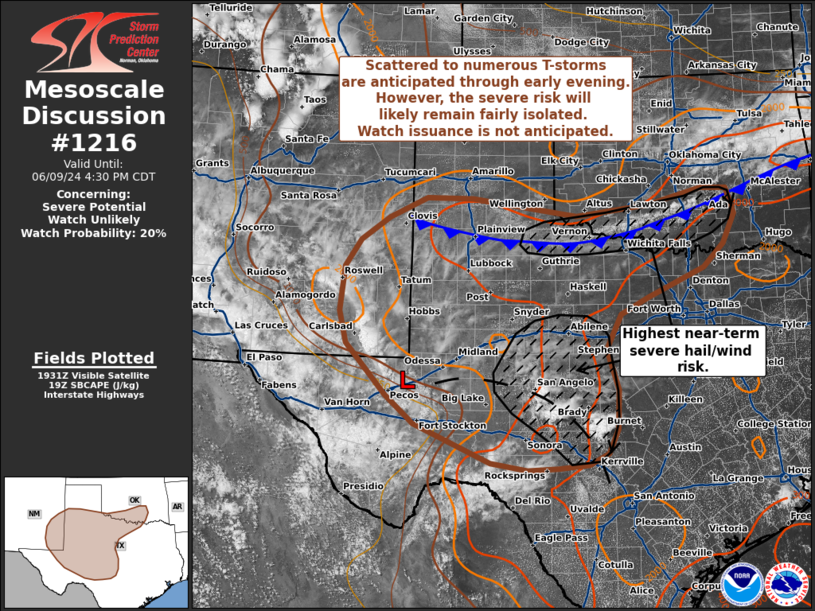
   SUMMARY...Scattered to numerous thunderstorms are anticipated
   through the late afternoon hours across southeast New Mexico into
   western and central Texas and southwest/southern Oklahoma. While
   sporadic hail and damaging winds are possible, storm
   organization/longevity should remain limited. Watch issuance is not
   currently anticipated.

   DISCUSSION...Latest GOES imagery shows a few attempts at sustained
   convective initiation across central to western TX along a diffuse
   surface trough/confluence zone to the east of a weak surface low
   over the Trans Pecos region. Additional cumulus development is noted
   along a cold front pushing southward through southern OK and
   northwest TX. More robust/sustained convection appears likely within
   the next 1-2 hours across both of these regions as diurnal heating
   and weak mesoscale ascent further erode lingering inhibition and
   surface-based parcels approach their convective temperatures
   (generally in the mid 90s).

   To the west, persistent cloud cover over NM has limited daytime
   heating to some degree, but filtered insolation will continue to
   destabilize a reasonably moist air mass (surface dewpoints are about
   the 75th percentile for early June across southeastern NM). A few
   early updrafts are noted in far southeast NM with additional/more
   numerous thunderstorm development within the upslope flow regime
   anticipated a little later this afternoon, most likely during the
   21-23 UTC period based off recent high-res guidance.

   Both regions are characterized by moderate to strong SBCAPE
   (2000-4000 J/kg), weak deep-layer wind shear (based on recent VWP
   observations), and deep, well-mixed boundary layers. Consequently,
   the expectation is for initially discrete to semi-discrete cells to
   pose an early severe hail risk before quickly becoming outflow
   dominant with additional redevelopment along outflow boundaries. One
   or more somewhat organized clusters may emerge and pose a more
   focused severe wind threat if consolidated cold pools can become
   established; however, this appears to be a low-predictability
   scenario given the potential for scattered thunderstorms over a
   broad region. Given the poor kinematic environment and
   low-confidence in where more focused severe wind corridors will
   emerge, watch issuance is not anticipated.

   ..Moore/Gleason.. 06/09/2024

   ...Please see www.spc.noaa.gov for graphic product...

   ATTN...WFO...FWD...OUN...EWX...SJT...LUB...AMA...MAF...ABQ...

   LAT...LON   30830296 31320355 32240440 32810454 33600445 34080412
               34500353 34860272 34840175 34529952 34719800 34999684
               34969630 34519614 33989640 33569682 33059803 32769861
               32149893 31429869 30729871 30309892 30109932 30049994
               30010059 30130135 30830296
|
|
|
Top/All Mesoscale Discussions/Forecast Products/Home |
|


