|
|
| Mesoscale Discussion 1215 | |
| < Previous MD | |

|
|
   Mesoscale Discussion 1215
   NWS Storm Prediction Center Norman OK
   0545 AM CDT Sun Jun 09 2024

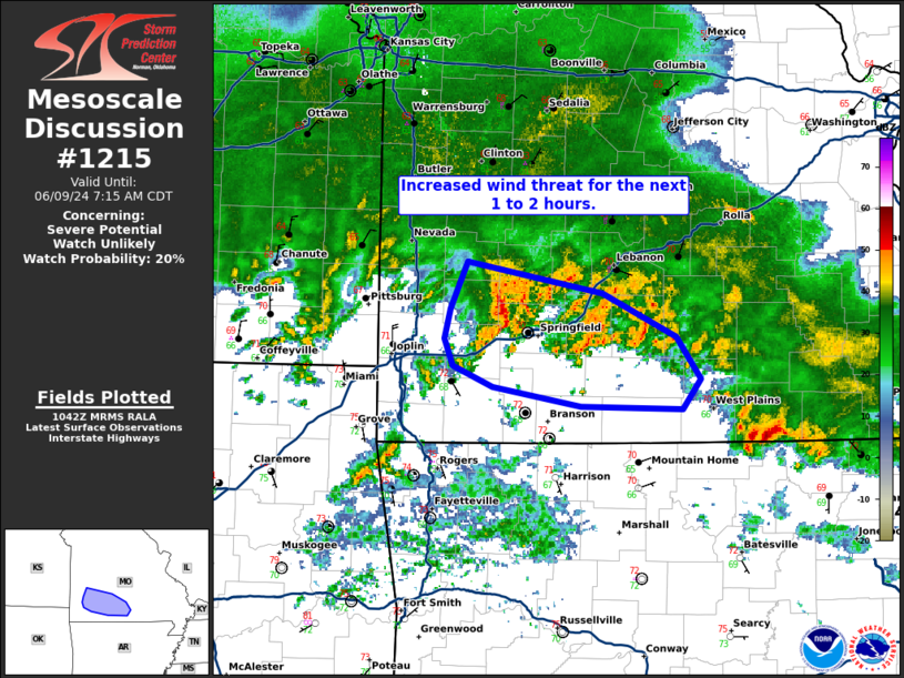
   Areas affected...parts of southwest Missouri

   Concerning...Severe potential...Watch unlikely

   Valid 091045Z - 091215Z

   Probability of Watch Issuance...20 percent

   SUMMARY...There is an increased damaging wind threat across parts of
   southwest Missouri over the next 1 to 2 hours.

   DISCUSSION...A confined region of increased damaging/severe wind
   threat exists along the warm front/outflow boundary across southwest
   Missouri. Greater than 50 knots of base velocity is being sampled
   from KSGF across western Greene County at less than 500 ft AGL.
   Therefore, it is reasonable to assume at least some of this wind is
   making it to the surface which would result in some damaging wind
   threat. The longevity of this wind threat remains questionable as
   its propagation is into the rain-cooled airmass to the east.
   Additional development/intensification is possible on the southern
   edge of the ongoing severe warned storm. However, convection in this
   area has been quite weak thus far, likely due to increasing
   inhibition with southern extent. Due to the relatively isolated and
   likely shorter duration of this threat, no watch is anticipated.

   ..Bentley/Hart.. 06/09/2024

   ...Please see www.spc.noaa.gov for graphic product...

   ATTN...WFO...SGF...

   LAT...LON   37709388 37489275 37209214 36929195 36729209 36749294
               36879367 37009400 37199407 37399401 37709388
|
|
|
Top/All Mesoscale Discussions/Forecast Products/Home |
|


