| Mesoscale Discussion 1213 | |
| < Previous MD | |

|
|
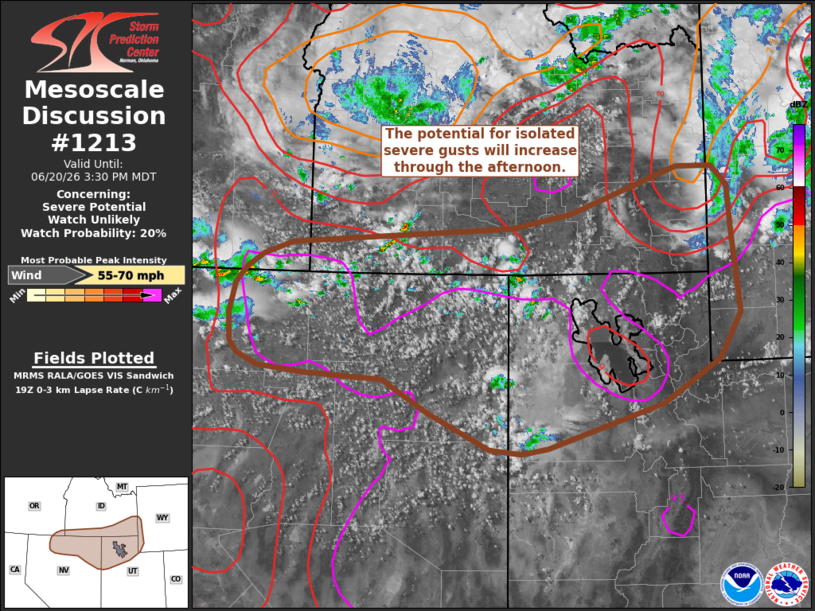
   Mesoscale Discussion 1213
   NWS Storm Prediction Center Norman OK
   0233 PM CDT Sat Jun 20 2026

   Areas affected...Northern Utah into southeast Idaho

   Concerning...Severe potential...Watch unlikely

   Valid 201933Z - 202130Z

   Probability of Watch Issuance...20 percent

   SUMMARY...Isolated strong to severe downburst winds will be possible
   through early evening across the northern Great Basin into far
   southwest Wyoming. This threat should remain sufficiently isolated
   to preclude watch issuance.

   DISCUSSION...The early stages of thunderstorm initiation are ongoing
   across northern NV and into adjacent portions of southern ID and
   northwest UT. This activity is largely being driven by large-scale
   ascent in proximity to a mid-level vorticity maximum evident in
   recent water-vapor imagery, and is being aided by localized
   orographic ascent within the higher terrain features. Across much of
   northeast NV into UT/ID, temperatures are warming into the mid 70s
   to low 80s with dewpoint depressions increasing into the 30-40 F
   range, indicative of deep boundary-layer mixing. Recent RAP
   mesoanalyses corroborate these observations and suggest 0-3 km lapse
   rates are nearly dry adiabatic.

   While dry low-level conditions are limiting overall buoyancy, the
   boundary-layer thermodynamic conditions are favorable for downdraft
   accelerations capable of producing strong to severe downburst winds.
   Additionally, 20-30 knots of bulk shear through the CAPE-bearing
   layer should provide some storm longevity, further supporting the
   potential for strong/severe winds. In general, thunderstorm coverage
   should remain isolated to perhaps widely scattered, and the
   downburst wind threat associated with any particular storm should
   remain relatively transient (10-30 minutes). These factors limit
   confidence in the need for a watch.

   ..Moore/Hart.. 06/20/2026

   ...Please see www.spc.noaa.gov for graphic product...

   ATTN...WFO...RIW...SLC...PIH...BOI...LKN...

   LAT...LON   41531057 41021089 40531174 40031345 39981385 40021433
               40441523 40811592 40871709 40931777 41061807 41201818
               41511820 41861812 42031794 42181770 42331727 42501398
               42661310 43191149 43181097 42971074 42511070 41531057

   MOST PROBABLE PEAK WIND GUST...55-70 MPH
|
|
|
Top/All Mesoscale Discussions/Forecast Products/Home |
|
Source link