|
|
| Mesoscale Discussion 1212 | |
| < Previous MD | |

|
|
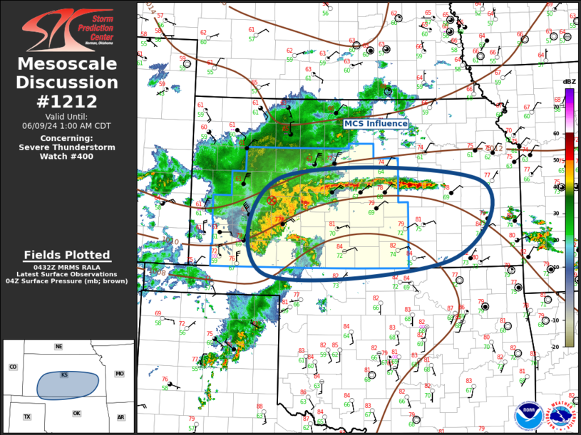
Mesoscale Discussion 1212 NWS Storm Prediction Center Norman OK 1134 PM CDT Sat Jun 08 2024 Areas affected...Kansas Concerning...Severe Thunderstorm Watch 400... Valid 090434Z - 090600Z The severe weather threat for Severe Thunderstorm Watch 400 continues. SUMMARY...Severe threat will spread across central into eastern portions of ww0400 over the next several hours. Large hail and damaging winds remain possible. DISCUSSION...Convection that evolved over the High Plains of eastern CO has grown upscale as it spreads downstream. Latest radar data suggests a maturing MCS is now located over western KS with an apparent MCV over northwest Hodgeman County. Over the last hour or so, an east-west band of convection has developed well ahead of the main complex and is beginning to intensify as far downstream as Chase County. Low-level warm advection will likely aid new development across southeast KS over the next few hours. Of more significance, a substantial precip shield has evolved over northwest KS and this may contribute to a surging squall line that is progressing across the DDC CWA. Severe winds have been noted with this convection across much of eastern CO into western KS. With time this band of convection may become oriented more north-south which would continue to favor very strong winds along the leading edge of this activity. ..Darrow.. 06/09/2024 ...Please see www.spc.noaa.gov for graphic product... ATTN...WFO...TOP...ICT...OUN...DDC...AMA... LAT...LON 38600003 38549552 37129620 36860035 38600003 |
|
|
Top/All Mesoscale Discussions/Forecast Products/Home |
|


