| Mesoscale Discussion 1210 | |
| < Previous MD Next MD > | |

|
|
Mesoscale Discussion 1210
NWS Storm Prediction Center Norman OK
1242 PM CDT Sat Jun 20 2026
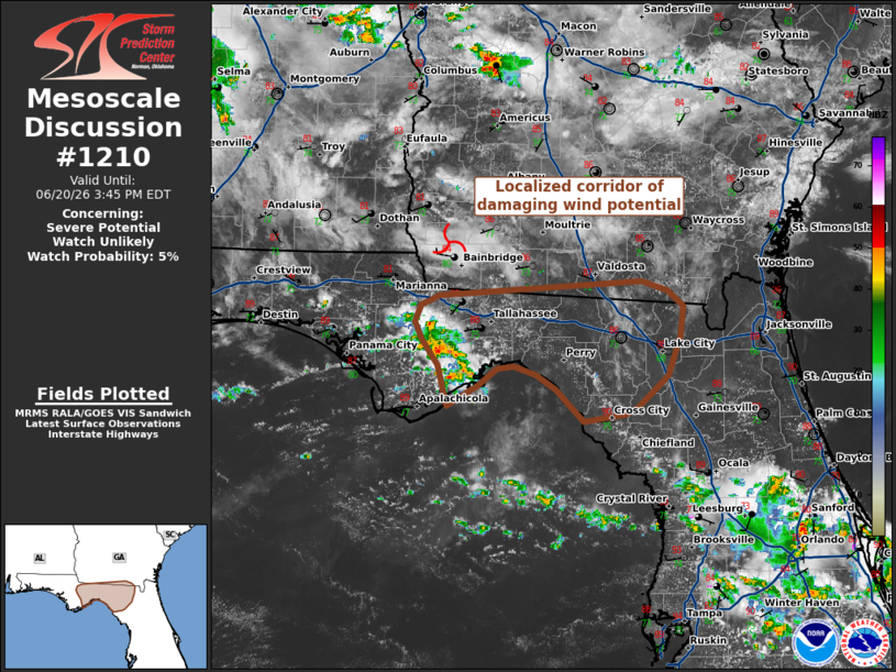
Areas affected...The Big Bend region of Florida into far southern
Georgia
Concerning...Severe potential...Watch unlikely
Valid 201742Z - 201945Z
Probability of Watch Issuance...5 percent
SUMMARY...A localized corridor of higher wind potential may be
emerging across the Big Bend region of Florida and into adjacent
portions of far southern Georgia. Watch issuance is not expected.
DISCUSSION...Recent GOES IR imagery shows steady deepening of
incipient convection to the west of Tallahassee, FL that has
developed within a weak low-level confluence zone. This activity may
be influenced by a weak MCV noted in visible imagery and regional
VWP observations across extreme southwest GA. Over the past hour,
the KTLH VWP has shown a slight increase in 6 km winds that is
supporting some hodograph elongation as the MCV passes to the north.
Consequently, it appears plausible that a loosely organized
convective band may emerge over the next 1-2 hours across the Big
Bend region as convection continues to intensify. Further warming of
the downstream environment will likely yield low-level lapse rates
on the order of 7-8 C/km that should support some potential for
damaging wind gusts over the next few hours. Despite this potential,
the modest kinematic environment and a pocket of drier, less buoyant
air far downstream across northern FL will likely limit the overall
intensity, duration, and spatial extent of this threat and negate
the need for watch issuance.
..Moore/Hart.. 06/20/2026
...Please see www.spc.noaa.gov for graphic product...
ATTN...WFO...JAX...TAE...
LAT...LON 29738470 30078479 30278494 30428500 30578495 30648476
30768283 30698258 30558243 30318246 29988258 29718287
29658298 29608338 29878365 29998385 30068406 30038422
29898439 29738470
|
|
|
Top/All Mesoscale Discussions/Forecast Products/Home |
|
Source link