| Mesoscale Discussion 1209 | |
| < Previous MD | |

|
|
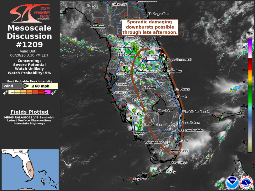
   Mesoscale Discussion 1209
   NWS Storm Prediction Center Norman OK
   1206 PM CDT Sat Jun 20 2026

   Areas affected...Eastern Florida Peninsula

   Concerning...Severe potential...Watch unlikely

   Valid 201706Z - 201930Z

   Probability of Watch Issuance...5 percent

   SUMMARY...Sporadic damaging wind gusts associated with wet
   downbursts will be possible through late afternoon. This threat will
   remain sufficiently isolated and transient to negate the need for a
   watch.

   DISCUSSION...Thunderstorm initiation has been well underway over the
   past hour per regional radar and GOES imagery. Minimal capping
   within a very moist environment, combined with weak ascent along a
   subtle confluence axis, has resulted in convective initiation
   slightly earlier than anticipated by most 12z solutions. Despite
   around 2000 J/kg MLCAPE, negligible deep-layer wind shear will
   promote mainly pulse convection and multi-cell clusters with several
   outflow boundaries from this initial activity already apparent in
   radar imagery. With surface temperatures still relatively early in
   the diurnal heating cycle, low-level thermodynamic conditions
   (primarily low-level lapse rates) are currently not optimal to
   support a more robust downburst threat. However, continued heating
   through the afternoon should yield pockets of higher MLCAPE and
   steeper low-level lapse rates that should favor a greater potential
   for strong to severe downbursts as convection spreads
   east/southeast. Based on latest radar/satellite trends, this appears
   most likely along the east-central to southeastern FL Peninsula.
   Regardless, the overall severe wind risk will likely remain fairly
   isolated and transient.

   ..Moore/Hart.. 06/20/2026

   ...Please see www.spc.noaa.gov for graphic product...

   ATTN...WFO...MFL...MLB...TBW...

   LAT...LON   25408019 25448049 25678077 26148116 26788136 27768181
               28088188 28538174 28778154 28858108 28858073 28438045
               28178045 27848037 27408018 27098007 26837999 26638000
               25718007 25408019

   MOST PROBABLE PEAK WIND GUST...UP TO 60 MPH
|
|
|
Top/All Mesoscale Discussions/Forecast Products/Home |
|
Source link