|
|
| Mesoscale Discussion 1208 | |
| < Previous MD | |

|
|
   Mesoscale Discussion 1208
   NWS Storm Prediction Center Norman OK
   0704 PM CDT Sat Jun 08 2024

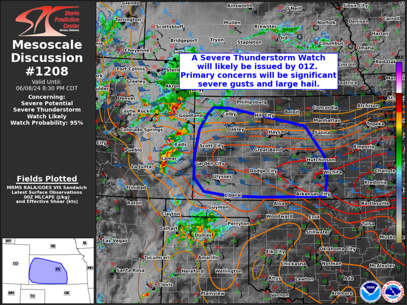
   Areas affected...The western half of Kansas

   Concerning...Severe potential...Severe Thunderstorm Watch likely

   Valid 090004Z - 090130Z

   Probability of Watch Issuance...95 percent

   SUMMARY...A Severe Thunderstorm Watch will likely be issued for
   parts of the area by 01Z. Primary concerns are significant severe
   gusts up to 80 mph and large hail.

   DISCUSSION...During the next few hours, a mix of supercells and
   bowing line segments currently tracking east-southeastward across
   eastern CO (in Severe Thunderstorm Watch 398) will continue across
   the western half of Kansas. Current expectation is for much of the
   ongoing activity to congeal into organized clusters as they continue
   eastward into tonight -- given strong/persistent outflow generation.
   The downstream environment features middle/upper 80s temperatures
   amid middle/upper 60s dewpoints beneath an EML/steep lapse rate
   plume. The resultant moderate/strong surface-based instability
   should support a continued severe risk with eastward extent into
   tonight. Around 50 kt of westerly effective shear should also favor
   organized clusters capable of significant winds gusts (up to 80 mph)
   and instances of large hail. It is still unclear if one consolidated
   MCS can develop, but if this scenario unfolds, more widespread
   severe wind can be expected. A Severe Thunderstorm Watch will likely
   be issued by 01Z for much of the area.

   ..Weinman/Bunting.. 06/09/2024

   ...Please see www.spc.noaa.gov for graphic product...

   ATTN...WFO...TOP...ICT...GID...DDC...GLD...

   LAT...LON   37630201 38290200 39020184 39480154 39670132 39650069
               39139793 38259723 37529717 37089726 37089948 37110071
               37240164 37630201
|
|
|
Top/All Mesoscale Discussions/Forecast Products/Home |
|


