| Mesoscale Discussion 1205 | |
| < Previous MD | |

|
|
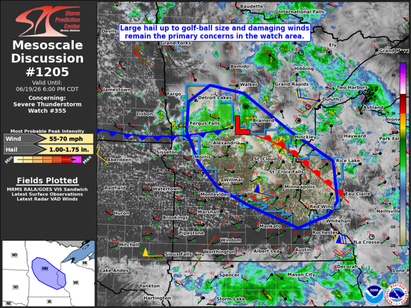
Mesoscale Discussion 1205 NWS Storm Prediction Center Norman OK 0356 PM CDT Fri Jun 19 2026 Areas affected...central Minnesota into west-central Wisconsin Concerning...Severe Thunderstorm Watch 355... Valid 192056Z - 192300Z The severe weather threat for Severe Thunderstorm Watch 355 continues. SUMMARY...Large hail up to golf-ball size and damaging wind gusts will remain the primary hazards as storms continue to spread southeast across the watch area this afternoon into evening. DISCUSSION...As of 20:45 UTC, mosaic radar data indicated a loosely organized cluster of thunderstorms across Otter Tail, Wadena, and Cass Counties with more intense, semi-discrete storms noted in Mille Lacs and Kanabec Counties. The semi-discrete storms appear to be located immediately downstream from a weak surface low, where low-level convergence and vertical shear are likely being maximized. Latest objective analysis suggests that the inflow air mass to these storms remains moderately unstable with MLCAPE of around 1000 J/kg, with increasing bulk-shear magnitudes with southward extent across the watch area. As such, the greatest potential for large hail up to golf-ball size is expected with the more discrete storms mentioned above, which are in closer proximity to the stronger vertical shear. Latest short-term model guidance continues to suggest an increased risk for damaging winds evolving late this afternoon into evening from the vicinity of the St. Croix River into portions of west-central WI as storms consolidate in to clusters or line segments. ..Mead.. 06/19/2026 ...Please see www.spc.noaa.gov for graphic product... ATTN...WFO...DLH...ARX...MPX...FGF... LAT...LON 44189284 44669425 45029518 45559577 46189614 46799610 47149546 46989444 46219305 45579179 44739168 44459194 44189284 MOST PROBABLE PEAK WIND GUST...55-70 MPH MOST PROBABLE PEAK HAIL SIZE...1.00-1.75 IN |
|
|
Top/All Mesoscale Discussions/Forecast Products/Home |
|
Source link