| Mesoscale Discussion 1201 | |
| < Previous MD | |

|
|
Mesoscale Discussion 1201
NWS Storm Prediction Center Norman OK
0207 PM CDT Fri Jun 19 2026
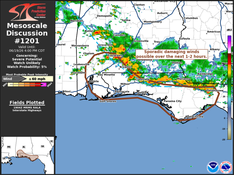
Areas affected...Southern Alabama into the Florida Panhandle
Concerning...Severe potential...Watch unlikely
Valid 191907Z - 192100Z
Probability of Watch Issuance...5 percent
SUMMARY...Sporadic damaging winds will be possible for the next
couple of hours as a band of thunderstorms approaches the Gulf
Coast.
DISCUSSION...Over the past 1-2 hours, a band of poorly organized
convection has been drifting southward across southern AL and into
the FL Panhandle. Surface observations have largely been reporting
wind gusts between 20-30 mph with the passage of the line over the
past 30 minutes. However, GOES IR imagery has shown a trend towards
colder cloud-top temperatures associated with stronger updraft
pulses as the line propagates south into a warming air mass where
temperatures are warming into the upper 80s and low 90s. Deep-layer
wind shear remains very poor across the region and will continue to
modulate the overall severe threat; however, this trends towards
stronger updrafts and warming low-level conditions suggests the
potential for very isolated bursts of damaging winds (most likely
35-55 mph) is likely increasing. Areas downstream of the convective
bands may see sporadic damaging gusts over the next couple of hours
as the storms continue to push southward towards the coast.
..Moore/Hart.. 06/19/2026
...Please see www.spc.noaa.gov for graphic product...
ATTN...WFO...TAE...MOB...
LAT...LON 30238756 30438792 30858815 31168815 31488786 31558754
31538720 31098676 30848638 30678564 30598467 30608404
30398387 30118401 29708467 29668515 29848548 30138583
30318646 30238756
MOST PROBABLE PEAK WIND GUST...UP TO 60 MPH
|
|
|
Top/All Mesoscale Discussions/Forecast Products/Home |
|
Source link