| Mesoscale Discussion 1198 | |
| < Previous MD Next MD > | |

|
|
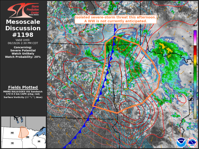
   Mesoscale Discussion 1198
   NWS Storm Prediction Center Norman OK
   1235 PM CDT Fri Jun 19 2026

   Areas affected...Red River Valley of eastern North Dakota and
   northwest Minnesota

   Concerning...Severe potential...Watch unlikely

   Valid 191735Z - 191930Z

   Probability of Watch Issuance...20 percent

   SUMMARY...The potential for isolated occurrences of marginally
   severe hail and perhaps a brief tornado is forecast to increase
   early this afternoon. Expected severe-weather coverage and intensity
   currently appear too limited to warrant a watch issuance.

   DISCUSSION...Recent trends in visible satellite and mosaic radar
   data indicate a gradual increase in storm coverage within a zone of
   forcing for ascent preceding a vigorous short-wave trough over
   central ND. Cooling temperatures aloft coupled with daytime heating
   are contributing to steepening low/mid-level lapse rates and MLCAPE
   of 500-1000 J/kg, a notable amount of which is contained within the
   lowest 3 km of the ground.

   Area VWPs and objective plan view data indicate that vertical shear
   is relatively weak, which should limit the potential for storm
   organization and a more robust severe-weather threat. Nonetheless,
   the presence of seasonably cold temperatures aloft (-20 to -22 C at
   500 mb) may support some marginally severe hail potential in the
   strongest storms. In addition, the colocation of relatively large
   low-level CAPE and vertical vorticity in the vicinity of existing
   surface boundaries suggests some potential for a brief tornado.

   Expected severe-weather coverage and intensity currently appear too
   limited to warrant a watch issuance. Greater severe-weather
   potential is expected to materialize farther to the southeast later
   this afternoon, which may necessitate a watch issuance.

   ..Mead.. 06/19/2026

   ...Please see www.spc.noaa.gov for graphic product...

   ATTN...WFO...DLH...FGF...BIS...

   LAT...LON   47419763 48299735 49069736 49369678 48999527 48299443
               47709401 47229413 46599510 46389604 46189660 46479805
               47419763
|
|
|
Top/All Mesoscale Discussions/Forecast Products/Home |
|
Source link