| Mesoscale Discussion 1194 | |
| < Previous MD | |

|
|
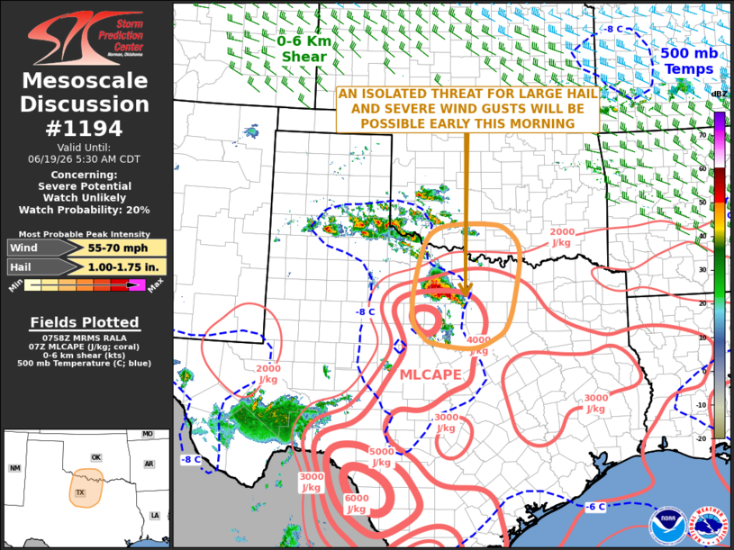
   Mesoscale Discussion 1194
   NWS Storm Prediction Center Norman OK
   0301 AM CDT Fri Jun 19 2026

   Areas affected...North-central Texas...Far Southern Oklahoma

   Concerning...Severe potential...Watch unlikely

   Valid 190801Z - 191030Z

   Probability of Watch Issuance...20 percent

   SUMMARY...An isolated threat for large hail and severe wind gusts
   will likely continue across north-central Texas over the next few
   hours, and could impact far southern Oklahoma as well. The threat is
   expected to remain too marginal for watch issuance.

   DISCUSSION...Latest surface analysis shows a quasi-stationary front
   located from west-central Texas northeastward into southeast
   Oklahoma. Nearly surface-based thunderstorms are developing close to
   the boundary to the south-southwest of Wichita Falls. The storms are
   located just to the north of a pocket of strong instability, where
   surface dewpoints are in the upper 70s F and the RAP has MLCAPE in
   the 4000 to 5000 J/kg range. In addition, RAP forecast soundings
   over north-central Texas have 700-500 mb lapse rates near 8 C/km.
   This thermodynamic environment will be favorable for an isolated
   large hail and a wind-damage threat. Although deep-layer shear is
   weak over much of north-central Texas, RAP forecast soundings a bit
   further east have 0-6 km shear in the 20 to 25 knot range. As the
   storms move eastward into a slightly more favorable environment, the
   severe threat is expected to be maintained or could increase some.
   However, large-scale ascent is limited over central and north Texas,
   which may keep any severe threat localized.

   ..Broyles/Gleason.. 06/19/2026

   ...Please see www.spc.noaa.gov for graphic product...

   ATTN...WFO...FWD...OUN...SJT...

   LAT...LON   34199910 34519878 34619828 34629752 34529707 34089671
               33129683 32489703 32219734 32019791 32109886 32289915
               32589937 33249936 34199910

   MOST PROBABLE PEAK WIND GUST...55-70 MPH
   MOST PROBABLE PEAK HAIL SIZE...1.00-1.75 IN
|
|
|
Top/All Mesoscale Discussions/Forecast Products/Home |
|
Source link