| Mesoscale Discussion 1189 | |
| < Previous MD | |

|
|
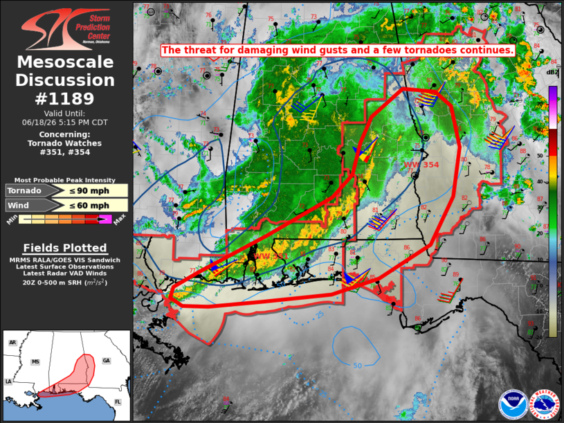
Mesoscale Discussion 1189 NWS Storm Prediction Center Norman OK 0348 PM CDT Thu Jun 18 2026 Areas affected...portions of the central Gulf Coast and Southeast Concerning...Tornado Watch 351...354... Valid 182048Z - 182215Z The severe weather threat for Tornado Watch 351, 354 continues. SUMMARY...The threat for damaging wind gusts and a few tornadoes continues across Tornado Watches 351 and 354. DISCUSSION...A modestly well-organized convective line remains ongoing from the central Gulf Coast into eastern Alabama as of 2035 UTC. While no severe gusts have been observed over the past several hours, moderate buoyancy and modestly enhanced effective shear preceding this convection will continue to support the maintenance of this convective line and additional clusters, with a threat for damaging wind gusts. This activity will spread east/northeastward through this evening in tandem with a mid-level disturbance and attendant southerly, low-level jet. The MXX/EVX/EOX VAD profiles are also sampling 125-150 m2/s2 0-500 m SRH ahead of this convection, which will continue to promote the potential for a few tornadoes. A relatively greater tornado risk may develop from eastern Alabama into western Georgia where the convective line is gradually developing a more favorable north-south orientation (more perpendicular to deep-layer shear vectors) and where surface winds are locally more backed. ..Chalmers.. 06/18/2026 ...Please see www.spc.noaa.gov for graphic product... ATTN...WFO...FFC...TAE...BMX...MOB...LIX... LAT...LON 30478890 31038773 31638657 31968622 32458609 32848588 33258533 33218475 32988446 32368433 31638446 30908487 30418577 30168658 30048779 29958870 29968915 30078936 30248932 30478890 MOST PROBABLE PEAK TORNADO INTENSITY...UP TO 90 MPH MOST PROBABLE PEAK WIND GUST...UP TO 60 MPH |
|
|
Top/All Mesoscale Discussions/Forecast Products/Home |
|
Source link