| Mesoscale Discussion 1188 | |
| < Previous MD | |

|
|
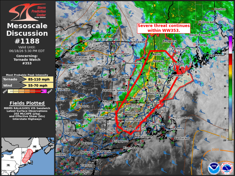
Mesoscale Discussion 1188 NWS Storm Prediction Center Norman OK 0306 PM CDT Thu Jun 18 2026 Areas affected...portions of New England Concerning...Tornado Watch 353... Valid 182006Z - 182130Z The severe weather threat for Tornado Watch 353 continues. SUMMARY...Thunderstorms to continue eastward for the next couple of hours. Threat for damaging wind and isolated tornadoes will continue. DISCUSSION...A line of thunderstorms continues eastward across eastern Maine into Massachusetts and northern Connecticut. These storms have produced reports of wind damage and gusts up to 60-64 mph this afternoon. While thermo profiles have been marginal, the near surface and mid-level flow remains strong. The low-level jet axis has begun to shift offshore, however, deep layer flow around 40-50 kts remains near the coast into portions of eastern/central Maine. Damaging wind and isolated tornado potential will continue for another 1-2 hours within WW353 before gradual weakening and storms shift offshore. ..Thornton.. 06/18/2026 ...Please see www.spc.noaa.gov for graphic product... ATTN...WFO...GYX...BOX...OKX...ALY... LAT...LON 42957247 43747183 44667128 44667048 44216989 43716983 42987040 42077157 41507225 41817293 42307302 42957247 MOST PROBABLE PEAK TORNADO INTENSITY...85-110 MPH MOST PROBABLE PEAK WIND GUST...55-70 MPH |
|
|
Top/All Mesoscale Discussions/Forecast Products/Home |
|
Source link