| Mesoscale Discussion 1184 | |
| < Previous MD Next MD > | |

|
|
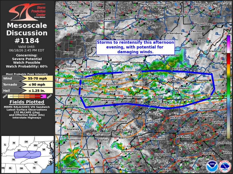
   Mesoscale Discussion 1184
   NWS Storm Prediction Center Norman OK
   1243 PM CDT Thu Jun 18 2026

   Areas affected...central/eastern Kentucky into West Virginia and the
   western Carolinas

   Concerning...Severe potential...Watch possible

   Valid 181743Z - 181845Z

   Probability of Watch Issuance...60 percent

   SUMMARY...Thunderstorm activity to re-intensify this afternoon with
   potential for damaging winds.

   DISCUSSION...Widely scattered thunderstorm activity continues across
   portions of central/eastern Kentucky into the Carolinas this
   afternoon. This is ongoing in the vicinity of a differential heating
   zone/residual outflow from morning storm activity. Daytime heating
   across this zone has allowed temperatures to warm into the mid 80s
   across southern Kentucky into northern Tennessee, with around
   1500-2000 J/kg of MLCAPE analyzed in SPC Mesoanalysis. Westerly deep
   layer flow continues to support around 30-40 kts of boundary shear
   to support organization. The parallel orientation of this shear to
   the boundary will likely support clustering of storms and multi-cell
   modes. Coverage of thunderstorms will likely increase this
   afternoon, with potential for several clusters spreading eastward
   through the afternoon. The main hazard is expected to be damaging
   wind.

   ..Thornton/Hart.. 06/18/2026

   ...Please see www.spc.noaa.gov for graphic product...

   ATTN...WFO...RNK...RLX...GSP...MRX...JKL...LMK...OHX...

   LAT...LON   37617939 37708033 37798192 37638508 37408598 36728600
               36198566 36398354 36198140 36278063 36577926 36957898
               37577909 37617939

   MOST PROBABLE PEAK TORNADO INTENSITY...UP TO 90 MPH
   MOST PROBABLE PEAK WIND GUST...55-70 MPH
   MOST PROBABLE PEAK HAIL SIZE...UP TO 1.25 IN
|
|
|
Top/All Mesoscale Discussions/Forecast Products/Home |
|
Source link