| Mesoscale Discussion 1182 | |
| < Previous MD | |

|
|
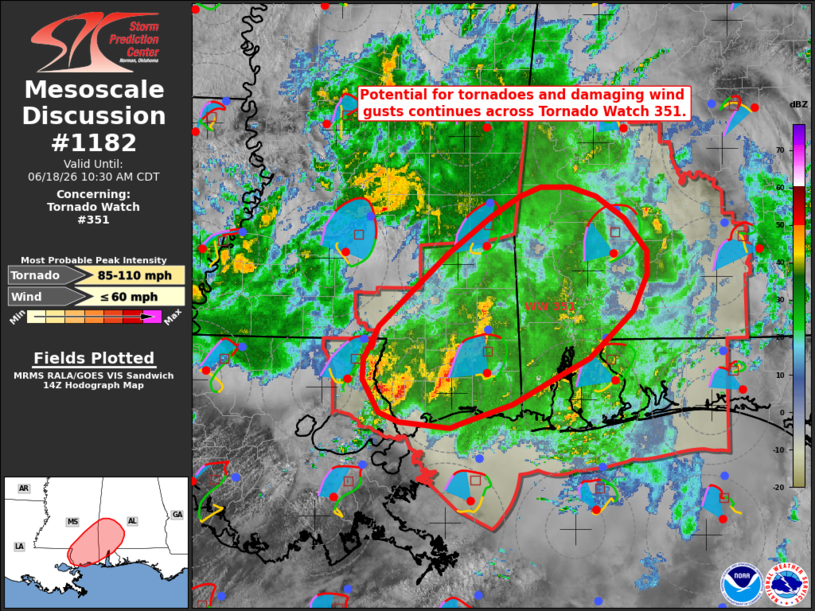
Mesoscale Discussion 1182 NWS Storm Prediction Center Norman OK 0903 AM CDT Thu Jun 18 2026 Areas affected...portions of the central Gulf Coast Concerning...Tornado Watch 351... Valid 181403Z - 181530Z The severe weather threat for Tornado Watch 351 continues. SUMMARY...The potential for tornadoes and damaging wind gusts continues across Tornado Watch 351. This risk is expected to spread inland and eastward through the morning. DISCUSSION...Regional radar imagery depicts several supercells embedded within a broader precipitation shield downstream of the remnants of Tropical Storm Arthur, currently analyzed over northern Louisiana. This activity has produced several reports of wind/potential tornado damage over southeastern Louisiana and southern Mississippi over the past several hours, with low-level Vrot signatures ranging form 30-40 kts at times. Expectation is for this activity to persist through the morning while spreading inland/eastward along a thermal/instability gradient (low-80s F temperatures and rich tropical moisture contributing to greater MLCAPE of 500-1500+ J/kg analyzed along the coast). Strong low-level flow and SRH (45-50 kts at 2 km AGL and 200 m2/s2 0-500 m SRH, respectively, sampled by the HDC/MOB VWPs) and looping hodographs will continue to favor the development/maintenance of low-level mesocyclones with the potential for tornadoes and damaging wind gusts. ..Chalmers.. 06/18/2026 ...Please see www.spc.noaa.gov for graphic product... ATTN...WFO...BMX...MOB...JAN...LIX... LAT...LON 30258909 30308960 30388979 30658995 30828995 31108979 31718913 32038869 32208841 32298820 32298791 32208766 32018738 31738715 31558716 31238729 30848773 30688805 30458848 30288898 30258909 MOST PROBABLE PEAK TORNADO INTENSITY...85-110 MPH MOST PROBABLE PEAK WIND GUST...UP TO 60 MPH |
|
|
Top/All Mesoscale Discussions/Forecast Products/Home |
|
Source link