|
|
| Mesoscale Discussion 1177 | |
| < Previous MD | |

|
|
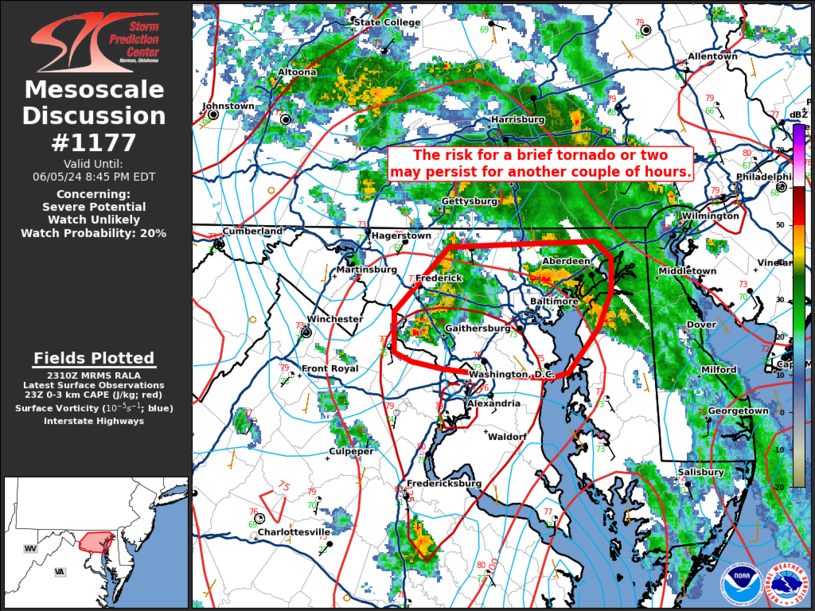
   Mesoscale Discussion 1177
   NWS Storm Prediction Center Norman OK
   0613 PM CDT Wed Jun 05 2024

   Areas affected...portions of far northeast VA and central MD

   Concerning...Severe potential...Watch unlikely

   Valid 052313Z - 060045Z

   Probability of Watch Issuance...20 percent

   SUMMARY...Brief tornadoes will remain possible for another couple of
   hours with small supercells near the VA/MD border. Convective
   coverage should remain very isolated and a WW is not expected.

   DISCUSSION...As of 2305 UTC, regional radar analysis showed a
   cluster of low-topped storms near the VA/MD border have taken on
   transient supercell characteristics. Several reports of funnel
   clouds and a brief tornado have been observed with theses storms
   over the last 90 min. The environment remains broadly favorable for
   convection with 1000-1500 J/kg of MLCAPE, much of which is focused
   below 4 km. Deep-layer shear is not supportive of longer-lived
   supercells, but area VADs do show clockwise curved hodographs in the
   lowest 1-2 km.  With a very moist air mass in place (low 70s F
   surface dewpoints) low cloud bases and strong low-level updrafts
   will allow for efficient stretching of stream-wise and ambient
   vorticity with these small storms. A brief tornado or two will
   remain possible for another couple of hours as these storms move
   east. Storms should gradually wane with the loss of diurnal heating.
   Given the limited convective coverage and the relatively transient
   nature of storm organization, a WW is not expected, though trends
   will continue to be monitored.

   ..Lyons/Bunting.. 06/05/2024

   ...Please see www.spc.noaa.gov for graphic product...

   ATTN...WFO...PHI...LWX...

   LAT...LON   39647655 39657614 39557603 39377603 39187611 38947632
               38917645 38937689 38957720 38997742 39047754 39277754
               39617716 39647655
|
|
|
Top/All Mesoscale Discussions/Forecast Products/Home |
|