| Mesoscale Discussion 1175 | |
| < Previous MD | |

|
|
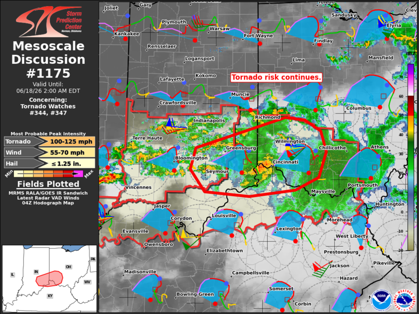
Mesoscale Discussion 1175 NWS Storm Prediction Center Norman OK 1127 PM CDT Wed Jun 17 2026 Areas affected...Southeastern Indiana...southwest Ohio...and far northern Kentucky Concerning...Tornado Watch 344...347... Valid 180427Z - 180600Z The severe weather threat for Tornado Watch 344, 347 continues. SUMMARY...The tornado risk is focusing across southeastern Indiana into southwestern Ohio tonight -- within Tornado Watches 344/347. DISCUSSION...Within a broad area of stratiform rain spreading across IN into OH, lower 70s temperatures amid upper 60s dewpoints are still yielding surface-based inflow parcels for a few deeper/embedded rotating updrafts. The ILN VWP is sampling the core of a 60-kt LLJ overspreading this activity, which is supporting a very large, clockwise curved hodograph (around 450 m2/s2 0-500m SRH). Despite marginal buoyancy, this wind profile is supporting efficient mesocylogenesis from southeastern IN into southwestern OH. The primary tornado risk should continue east-northeastward beneath the core of the LLJ and in a region of enhanced surface pressure falls tonight. Given the strong low-level shear/streamwise vorticity and supercell structures, a strong tornado remains possible with the longer-lived storms. ..Weinman.. 06/18/2026 ...Please see www.spc.noaa.gov for graphic product... ATTN...WFO...ILN...LMK...IND... LAT...LON 38628498 38698588 39048618 39388607 39878423 39838384 39658351 39338339 38928356 38718403 38628498 MOST PROBABLE PEAK TORNADO INTENSITY...100-125 MPH MOST PROBABLE PEAK WIND GUST...55-70 MPH MOST PROBABLE PEAK HAIL SIZE...UP TO 1.25 IN |
|
|
Top/All Mesoscale Discussions/Forecast Products/Home |
|
Source link