| Mesoscale Discussion 1170 | |
| < Previous MD | |

|
|
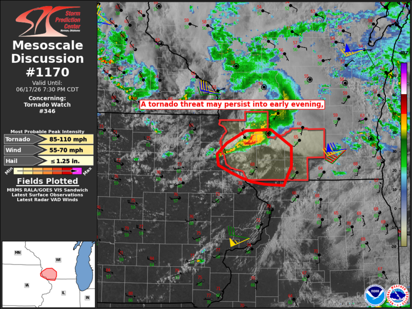
Mesoscale Discussion 1170 NWS Storm Prediction Center Norman OK 0555 PM CDT Wed Jun 17 2026 Areas affected...Parts of southwest WI and vicinity Concerning...Tornado Watch 346... Valid 172255Z - 180030Z The severe weather threat for Tornado Watch 346 continues. SUMMARY...Ongoing tornado potential may continue through early evening. Isolated hail and damaging wind are also possible. DISCUSSION...A noticeable uptick in storm organization has recently occurred across extreme northeast IA, with supercell evolution and development of a relatively long-lived tornado. The embedded supercell is now moving into southwest WI. While instability remains rather modest, favorable deep-layer shear and proximity to low-level vorticity in the vicinity of a surface low has helped to increase tornado potential, and some tornado threat may spread across a larger portion of southwest WI through early evening, where some modest airmass recovery has occurred. A Tornado Watch was recently issued in order to address the short-term tornado threat. Isolated hail and damaging wind also remain possible. ..Dean.. 06/17/2026 ...Please see www.spc.noaa.gov for graphic product... ATTN...WFO...MKX...DVN...ARX... LAT...LON 43069104 43269065 43279013 43028970 42728970 42428985 42449025 42479053 42549074 42629096 42739122 42909125 43069104 MOST PROBABLE PEAK TORNADO INTENSITY...85-110 MPH MOST PROBABLE PEAK WIND GUST...55-70 MPH MOST PROBABLE PEAK HAIL SIZE...UP TO 1.25 IN |
|
|
Top/All Mesoscale Discussions/Forecast Products/Home |
|
Source link