| Mesoscale Discussion 117 | |
| < Previous MD | |

|
|
Mesoscale Discussion 0117
NWS Storm Prediction Center Norman OK
0413 AM CST Mon Feb 23 2026
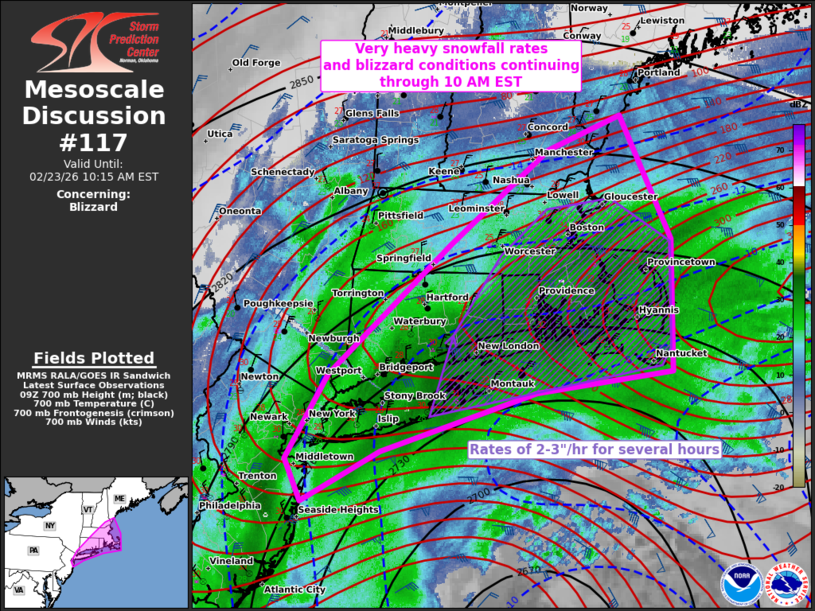
Areas affected...parts of the Northeast and southern New England
Concerning...Blizzard
Valid 231013Z - 231515Z
SUMMARY...Very heavy snowfall rates of 2-3 inches per hour and
widespread blizzard conditions should persist across Long Island and
southern New England through 10 AM EST.
DISCUSSION...Classic bomb cyclone/nor'easter off the Northeast coast
will slow its deepening over the next few hours as it tracks
northeastward off the southern New England coast through midday. As
this occurs, multiple bands of very heavy snow from NJ to southeast
MA should consolidate into one primary band across Long Island to
eastern MA through mid-morning. Extremely enlarged low-level
hodographs are indicative of the impressive warm conveyor north of
the cyclone. In addition, very high KDP values detected within and
somewhat below the dendritic growth zone amid base reflectivity
values around 35 dBZ all point to highly prolific snowfall rates of
2-3 in/hr. From eastern Long Island through eastern MA, this appears
likely to persist for several hours. Measured severe wind gusts
should persist in this same region, supporting widespread blizzard
conditions.
The aforementioned slowing of cyclogenesis and northeastward track
will eventually yield a more progressive tapering of very heavy
snowfall rates from the southwest towards late morning.
..Grams.. 02/23/2026
...Please see www.spc.noaa.gov for graphic product...
ATTN...WFO...GYX...BOX...OKX...ALY...PHI...
LAT...LON 43367044 43067126 42267238 41157375 40447422 40087404
40507316 41007141 41196988 42316988 43367044
|
|
|
Top/All Mesoscale Discussions/Forecast Products/Home |
|
Source link