| Mesoscale Discussion 1163 | |
| < Previous MD | |

|
|
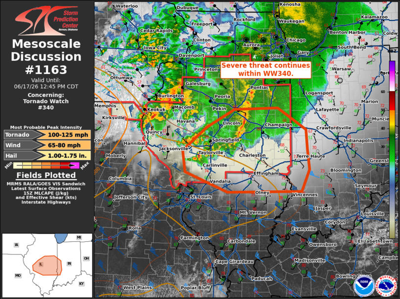
Mesoscale Discussion 1163 NWS Storm Prediction Center Norman OK 1043 AM CDT Wed Jun 17 2026 Areas affected...central Illinois into western Indiana Concerning...Tornado Watch 340... Valid 171543Z - 171745Z The severe weather threat for Tornado Watch 340 continues. SUMMARY...Damaging wind and tornado potential continues within WW340. DISCUSSION...Several broken thunderstorm clusters continue across south-central Illinois. The leading line of this convection appears to still be tied to the stronger cold pool/outflow producing gusts 60-65 mph in the last hour. The air mass across southern Illinois into Indiana is only marginally unstable, however, temperatures are warming into the mid to upper 70s F under mostly sunny skies with dew points in the mid to upper 60s F. Additionally, the low level jet axis (as shown in SPC Mesoanalysis and sampled from VAD profiles from LSX and ILX) still extends into central/southern Illinois with ample deep layer shear for organization, which may overcome the more marginal air mass. Hi-res CAM guidance suggests this cluster will weaken with time into eastern Illinois. Though guidance suggests weakening, the continued low-level jet influence and heating ahead of the line leads to low confidence in exactly when severe potential will decrease downstream. Trends will be monitored, with potential for a watch to be issued downstream of WW340. Within WW340, tornado potential continues along the southern edge of the current ongoing cluster. Here, more favorable low-level shear may support a tornado or two within more discrete cells. ..Thornton/Hart.. 06/17/2026 ...Please see www.spc.noaa.gov for graphic product... ATTN...WFO...IND...LOT...ILX...LSX... LAT...LON 39649038 40128976 40508902 40528786 40078711 39678708 39268703 38808724 38798920 39219031 39649038 MOST PROBABLE PEAK TORNADO INTENSITY...100-125 MPH MOST PROBABLE PEAK WIND GUST...65-80 MPH MOST PROBABLE PEAK HAIL SIZE...1.00-1.75 IN |
|
|
Top/All Mesoscale Discussions/Forecast Products/Home |
|
Source link