| Mesoscale Discussion 1161 | |
| < Previous MD | |

|
|
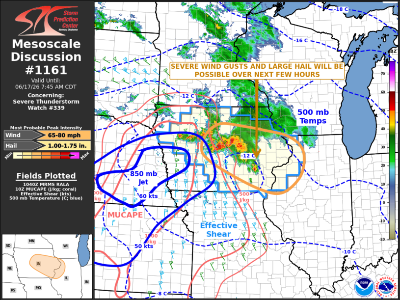
Mesoscale Discussion 1161 NWS Storm Prediction Center Norman OK 0542 AM CDT Wed Jun 17 2026 Areas affected...Central and Eastern Iowa...Northwest Illinois Concerning...Severe Thunderstorm Watch 339... Valid 171042Z - 171245Z The severe weather threat for Severe Thunderstorm Watch 339 continues. SUMMARY...A threat severe wind gusts and isolated large hail will continue across central Iowa over the next hour, and is expected to increase over eastern Iowa and northwest Illinois as daybreak approaches. DISCUSSION...A cluster of severe storms is currently located over central Iowa, along the eastern edge of an unstable airmass. The RAP shows moderate instability over much of western and central Iowa, where MUCAPE is currently estimated in the 1000 to 2000 J/kg range. As an 850 mb jet strengthens across the mid Missouri Valley early this morning, MUCAPE will steadily increase and should reach the 2000 to 3000 J/kg range around daybreak from central Iowa into northwest Illinois. This will provide additional fuel to the ongoing convection, helping the storms to become more organized with time. The instability combined with a strong wind field (effective shear 55 to 65 knots) will result in a potential for supercells with isolated large hail. Supercells will be embedded in the ongoing line segment. The line segment may begin to take on a bowing shape is it move across southeast Iowa. This could mean that severe wind gusts will become the greatest threat as the line moves across the eastern part of weather watch 339. A potential will exist for significant wind gusts in excess of 65 knots. ..Broyles/Guyer.. 06/17/2026 ...Please see www.spc.noaa.gov for graphic product... ATTN...WFO...LOT...ILX...MKX...DVN...ARX...DMX... LAT...LON 40539069 41048984 41698960 42178979 42519041 42689131 42839236 42919343 42699400 42329428 42039433 41789418 41389349 40719177 40539069 MOST PROBABLE PEAK WIND GUST...65-80 MPH MOST PROBABLE PEAK HAIL SIZE...1.00-1.75 IN |
|
|
Top/All Mesoscale Discussions/Forecast Products/Home |
|
Source link