| Mesoscale Discussion 1160 | |
| < Previous MD | |

|
|
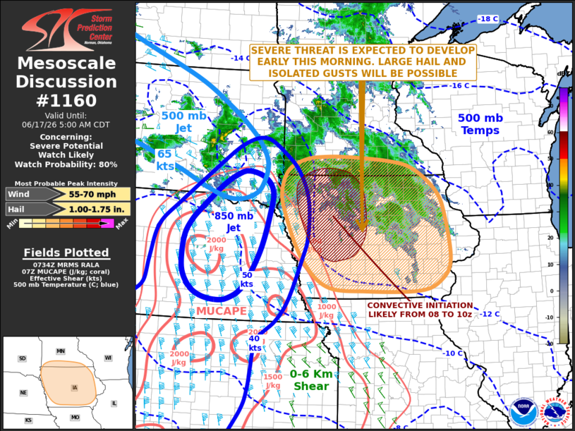
   Mesoscale Discussion 1160
   NWS Storm Prediction Center Norman OK
   0236 AM CDT Wed Jun 17 2026

   Areas affected...Iowa...Far Southern Minnesota

   Concerning...Severe potential...Watch likely

   Valid 170736Z - 171000Z

   Probability of Watch Issuance...80 percent

   SUMMARY...A severe threat is expected to develop over parts of Iowa
   and far southern Minnesota early this morning. Large hail and
   isolated severe wind gusts will be possible. Watch issuance will
   likely be needed, probably between 08Z and 09Z.

   DISCUSSION...A mid-level shortwave trough and an associated 65 to 75
   knot mid-level jet will move east-southeastward into the mid
   Missouri Valley early this morning. Ahead of the trough, an 850 mb
   jet will shift eastward across Iowa and steadily strengthen. As the
   mid-level jet approaches, lift associated with the nose of the
   low-level jet will support scattered thunderstorm development over
   parts of western and central Iowa into far southern Minnesota. This
   convection is expected to become more organized as it moves into
   eastern Iowa toward daybreak. As the low-level jet strengthens,
   moisture and instability will rapidly increase over Iowa. MUCAPE
   over much of Iowa is expected to reach the 2000 to 3000 J/kg range
   just prior to daybreak. This, combined with 700-500 mb lapse rates
   around 8 C/km, evident on forecast soundings, will be favorable for
   supercells with large hail. Although the storms will remain
   elevated, a few strong wind gusts will also be possible, mainly with
   any supercell that can become robust.

   ..Broyles/Guyer.. 06/17/2026

   ...Please see www.spc.noaa.gov for graphic product...

   ATTN...WFO...DVN...ARX...MPX...DMX...FSD...OAX...

   LAT...LON   43949431 43849299 43649223 43129152 42569125 41509108
               41009137 40769205 40749371 40869501 41559583 42689638
               43199646 43639624 43869572 43949514 43949431

   MOST PROBABLE PEAK WIND GUST...55-70 MPH
   MOST PROBABLE PEAK HAIL SIZE...1.00-1.75 IN
|
|
|
Top/All Mesoscale Discussions/Forecast Products/Home |
|
Source link