| Mesoscale Discussion 116 | |
| < Previous MD | |

|
|
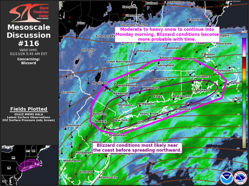
   Mesoscale Discussion 0116
   NWS Storm Prediction Center Norman OK
   1145 PM CST Sun Feb 22 2026

   Areas affected...New York City Vicinity into southern New England

   Concerning...Blizzard

   Valid 230545Z - 231045Z

   SUMMARY...Moderate to heavy snowfall will continue from the NYC
   Metro vicinity into southern New England. Snowfall rates of 1-2
   inches per hour are likely with localized 2+ inches per hour
   possible. Greater rates will spread north with time. Blizzard
   conditions will also become more prevalent, particularly near the
   coast.

   DISCUSSION...Over the past 5 hours, the surface cyclone off the
   Mid-Atlantic coast has deepened approximately 9 mb per objective
   analysis. Bands of moderate to heavy snow continue to pivot into the
   NYC metro vicinity as well as southern New England. Moderate snow
   observations are beginning to occur into Massachusetts. As the upper
   trough continues to intensify and become more negatively tilted, the
   surface cyclone will deepen further into Monday morning. A long
   duration of at least moderate snowfall can be expected. Closer to
   4-7 AM EST, a zone of very favorable ascent is expected to set up
   over southern New England. Snowfall rates of 1-2 inches per hour are
   likely along with the potential for localized 2+ inches per hour.
   Greater snowfall rates will also gradually shift northward as the
   system slowly lifts northeastward.

   Beyond significant snowfall rates, surface winds have already begun
   to increase from the Mid-Atlantic into southern New England. Current
   observations show winds gusting into the mid 30s to low 40s kts in
   Long Island. This trend should continue over the next several hours.
   Blizzard conditions will remain more likely near the coast, but
   inland areas will become increasingly impacted by strong winds and
   reduced visibility later this morning.

   ..Wendt.. 02/23/2026

   ...Please see www.spc.noaa.gov for graphic product...

   ATTN...WFO...BOX...OKX...ALY...PHI...

   LAT...LON   40447378 40557434 40767470 41187464 41617431 41777408
               42057317 42257271 42327212 42307140 41997061 41757033
               41347048 40447378
|
|
|
Top/All Mesoscale Discussions/Forecast Products/Home |
|
Source link