|
|
| Mesoscale Discussion 1158 | |
| < Previous MD | |

|
|
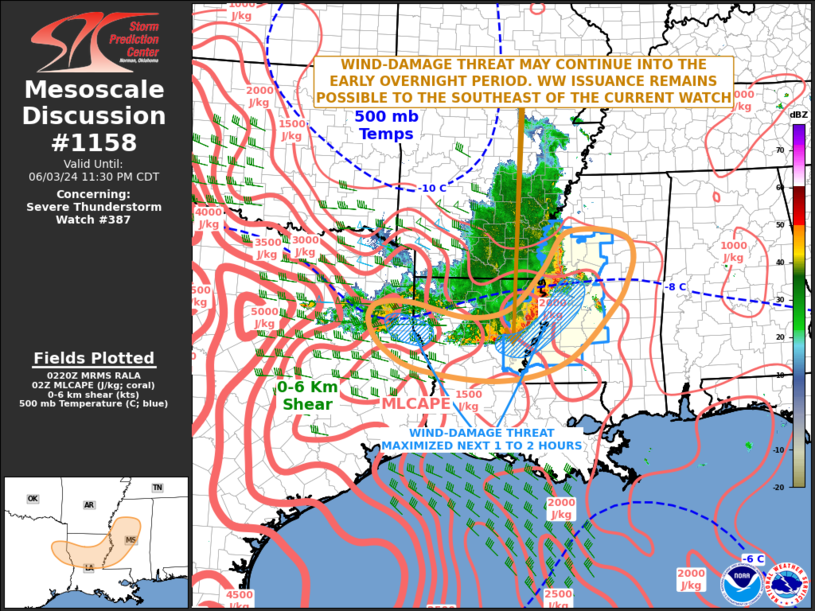
Mesoscale Discussion 1158 NWS Storm Prediction Center Norman OK 0923 PM CDT Mon Jun 03 2024 Areas affected...East Texas...North-central Louisiana...Western and Central Mississippi Concerning...Severe Thunderstorm Watch 387... Valid 040223Z - 040430Z The severe weather threat for Severe Thunderstorm Watch 387 continues. SUMMARY...An isolated wind-damage threat will be possible as a linear MCS moves into the central Gulf Coast states during the overnight period. The ongoing severe thunderstorm watch has been extended in area into south-central Mississippi, and may also need to be extended in time over parts of far eastern Texas and far western Louisiana. DISCUSSION...Mosaic radar imagery over the lower Ohio and Sabine River Valleys shows two organized line segments. The first is a larger-scale line associated with an MCS that is moving into western Mississippi. The second is a relatively small-scale bowing line segment over northeast Texas. These two features are located within a moderately unstable airmass, with the RAP analyzing MLCAPE in the 2000 to 3000 J/kg range. In addition, the WSR-88D VWP at Fort Polk, LA and 00Z sounding at Jackson, MS have 0-6 km shear near 35 knots, and gradually veering winds with height in the lowest 3 km. This wind profile will be continue to be favorable for linear organization, associated with an isolated wind-damage threat late this evening into the overnight period. The threat should be greatest from eastern Louisiana and western Mississippi, although a secondary threat area will exist near the Sabine River in western Louisiana. ..Broyles.. 06/04/2024 ...Please see www.spc.noaa.gov for graphic product... ATTN...WFO...MEG...JAN...LIX...LCH...SHV... LAT...LON 32419187 32269283 32539408 32529478 32339503 32039502 31629469 31239391 31049209 31409059 32448948 33008914 33458903 33788918 33938974 33939042 33759073 33149113 32419187 |
|
|
Top/All Mesoscale Discussions/Forecast Products/Home |
|


