| Mesoscale Discussion 1157 | |
| < Previous MD | |

|
|
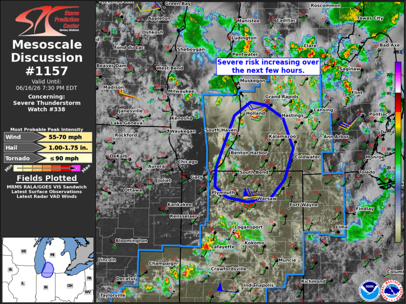
Mesoscale Discussion 1157 NWS Storm Prediction Center Norman OK 0453 PM CDT Tue Jun 16 2026 Areas affected...Parts of southwestern lower Michigan and northern Indiana Concerning...Severe Thunderstorm Watch 338... Valid 162153Z - 162330Z The severe weather threat for Severe Thunderstorm Watch 338 continues. SUMMARY...Risk of damaging winds and isolated severe hail should increase over the next few hours -- within Severe Thunderstorm Watch #338. DISCUSSION...Ahead of a compact midlevel shortwave trough advancing eastward across the Midwest, isolated cells are developing across southern Lake Michigan. As this activity spreads/develops eastward over the next few hours, a pocket of cold midlevel temperatures (around -20C at 500mb) and resultant steep lapse rates should promote some increase in updraft intensity. Despite modest buoyancy, the steepening midlevel lapse rates combined with strengthening low/midlevel flow preceding the trough (around 30-40 kt in the lowest 3 km AGL per nearby VWP) should promote damaging gusts and isolated severe hail with a mix of cells and small clusters. ..Weinman.. 06/16/2026 ...Please see www.spc.noaa.gov for graphic product... ATTN...WFO...IWX...GRR... LAT...LON 41508678 41818676 42698635 42938598 42888564 42668523 42148501 41628520 41288554 41238606 41328652 41508678 MOST PROBABLE PEAK TORNADO INTENSITY...UP TO 90 MPH MOST PROBABLE PEAK WIND GUST...55-70 MPH MOST PROBABLE PEAK HAIL SIZE...1.00-1.75 IN |
|
|
Top/All Mesoscale Discussions/Forecast Products/Home |
|
Source link