|
|
| Mesoscale Discussion 1154 | |
| < Previous MD | |

|
|
   Mesoscale Discussion 1154
   NWS Storm Prediction Center Norman OK
   0509 PM CDT Mon Jun 03 2024

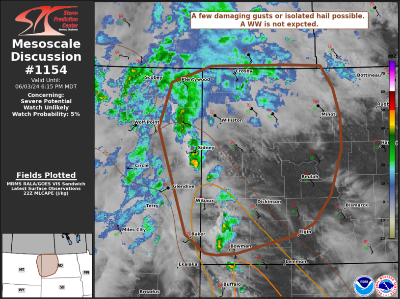
   Areas affected...Far eastern MT and western ND

   Concerning...Severe potential...Watch unlikely

   Valid 032209Z - 040015Z

   Probability of Watch Issuance...5 percent

   SUMMARY...Scattered storms are expected this afternoon and
   continuing into the evening. A few damaging gusts and isolated hail
   are possible. A Watch is unlikely.

   DISCUSSION...As of 22 UTC, regional radar analysis showed isolated
   thunderstorms had initiated on the eastern edge of a persistent
   cloud shield near the MT/ND border. Strong diurnal heating has
   allowed surface temperatures to warm into the upper 70s to low 80s
   F. While surface moisture has mixed somewhat, low 50s F surface
   dewpoints and weak upslope flow are contributing to weak
   destabilization. These storms, and additional development may
   continue eastward into western ND with a risk for damaging winds
   given the relatively high cloud bases. While buoyancy is modest
   (~500-1000 J/kg of MLCAPE) occasional hail will be possible with the
   stronger updrafts. Given the somewhat limited buoyancy and
   uncertainty on storm coverage, a WW appears unlikely this evening.

   ..Lyons/Hart.. 06/03/2024

   ...Please see www.spc.noaa.gov for graphic product...

   ATTN...WFO...BIS...BYZ...GGW...

   LAT...LON   48070503 48770475 49030383 49050203 49030127 48680100
               48240084 47750082 47020108 46570148 46380200 46120322
               46090367 46120395 46400439 48070503
|
|
|
Top/All Mesoscale Discussions/Forecast Products/Home |
|


