| Mesoscale Discussion 1151 | |
| < Previous MD | |

|
|
Mesoscale Discussion 1151
NWS Storm Prediction Center Norman OK
0320 PM CDT Mon Jun 15 2026
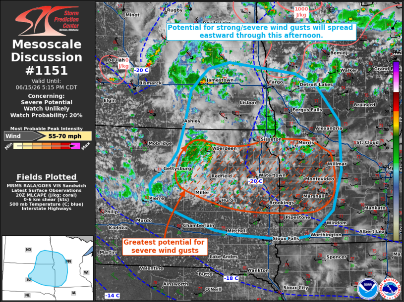
Areas affected...portions of the northern Great Plains
Concerning...Severe potential...Watch unlikely
Valid 152020Z - 152215Z
Probability of Watch Issuance...20 percent
SUMMARY...The potential for strong to severe wind gusts will spread
eastward this afternoon, with the greatest risk likely from
northeastern South Dakota into western Minnesota.
DISCUSSION...Convective coverage has increased across portions of
the northern Great Plains through the early afternoon, with widely
scattered showers and thunderstorms noted via regional radar
imagery. While buoyancy remains generally weak at around a couple
hundred J/kg MLCAPE (per a modified 18z ABR sounding), high LCLs and
steep low-level lapse rates (2500+ m and 9+ C/km, respectively) are
supporting efficient downward momentum transport of strengthening
mid-level flow (30-40 kts sampled at 3 km AGL by the BIS/ABR VADs),
with several wind gusts of 60-69 mph measured over the past 1-2
hours. This activity and the associated threat for isolated
strong/severe wind gusts will spread eastward into eastern South
Dakota, southeastern North Dakota, and western Minnesota over the
next 1-3 hours. The greatest potential likely exists downstream of a
marginally stronger cluster of convection approaching Aberdeen,
South Dakota. Watch issuance remains unlikely owing to the isolated
nature of the severe threat.
..Chalmers/Mosier.. 06/15/2026
...Please see www.spc.noaa.gov for graphic product...
ATTN...WFO...MPX...FGF...FSD...ABR...BIS...
LAT...LON 43619594 43639674 43699768 43799835 43969896 44199960
44360007 44540028 44720032 44880018 44989999 45239968
45459951 45739941 46149929 46759913 47019888 47229862
47359798 47129596 46859529 46089462 45059460 44209486
43679554 43619594
MOST PROBABLE PEAK WIND GUST...55-70 MPH
|
|
|
Top/All Mesoscale Discussions/Forecast Products/Home |
|
Source link