| Mesoscale Discussion 115 | |
| < Previous MD | |
|
|
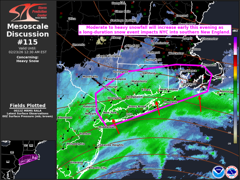
   Mesoscale Discussion 0115
   NWS Storm Prediction Center Norman OK
   0624 PM CST Sun Feb 22 2026

   Areas affected...New York City into Southern New England

   Concerning...Heavy snow

   Valid 230024Z - 230530Z

   SUMMARY...A long-duration moderate/heavy snowfall event will
   increasingly impact NYC into parts of southern New England this
   evening into Monday morning. 1-2 inch per hour snowfall rates will
   be likely, particularly after midnight EST.

   DISCUSSION...Recent regional radar imagery from the northern
   Mid-Atlantic/southern New England shows a band of moderate to heavy
   snow moving slowly northward into Long Island. Already, recent
   surface observations reported 1 inch in the last hour at Islip,
   LaGuardia, and JFK. This band should continue to impact parts of
   southern New England this evening. The highest snowfall rates will
   at least initially remain near the coast. With time, the 994 mb low
   analyzed off the Mid-Atlantic coast will deepen, particularly after
   11 pm/midnight EST. This will eventually promote a broader zone of
   stronger isentropic ascent that will promote more widespread
   moderate/heavy snow farther north. Surface winds will also
   concurrently increase with the deepening of the low. Blizzard
   conditions will be possible late this evening into Monday morning.

   ..Wendt.. 02/23/2026

   ...Please see www.spc.noaa.gov for graphic product...

   ATTN...WFO...BOX...OKX...ALY...

   LAT...LON   40437381 40837418 41297422 41837324 42027152 41987060
               41757033 41347048 40437381
|
|
|
Top/All Mesoscale Discussions/Forecast Products/Home |
|
Source link