|
|
| Mesoscale Discussion 1147 | |
| < Previous MD | |

|
|
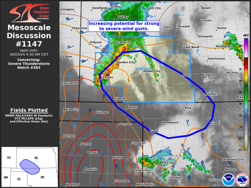
Mesoscale Discussion 1147 NWS Storm Prediction Center Norman OK 0300 AM CDT Mon Jun 03 2024 Areas affected...Southwest KS to northwest OK Concerning...Severe Thunderstorm Watch 383... Valid 030800Z - 030930Z The severe weather threat for Severe Thunderstorm Watch 383 continues. SUMMARY...Increasing potential for strong to severe wind gusts is expected through dawn as a developing QLCS intensifies across southwest Kansas. It appears this should eventually track towards northwest Oklahoma and an additional severe thunderstorm watch will be considered as it approaches. DISCUSSION...A 150-km long developing QLCS is ongoing across southwest KS. While it is initially rooted from elevated parcels and MRMS MESH cores have flirted around 1 inch, strong surface wind gusts have been observed (up to 55 mph at the Ulysses AWOS). This QLCS should intensify as it impinges on increasing buoyancy advecting across the Panhandles amid a 45-50 kt south-southwesterly low-level jet per Amarillo VWP data. Surface wind gusts of 55-70 mph should become more numerous into daybreak. While the bulk of 00Z CAM guidance indicated MCS development spreading more easterly across southern KS, the 06Z HRRR along with 00Z NSSL-MPAS suggest a more southeasterly track into northwest OK. Given the placement of both the MLCAPE/MUCAPE gradient and residual outflows from prior MCSs, this scenario appears more likely. ..Grams/Thompson.. 06/03/2024 ...Please see www.spc.noaa.gov for graphic product... ATTN...WFO...ICT...OUN...DDC...AMA... LAT...LON 38280065 38310006 37739874 37329808 36939772 36579780 36339802 36149857 36089920 36309981 36880080 37330129 37690139 38280065 |
|
|
Top/All Mesoscale Discussions/Forecast Products/Home |
|


